

Evaluation of Loess Landslide Susceptibility Based on Optimised MaxEnt Model: A Case Study of Wuqi County in Shaanxi Province
-
摘要:
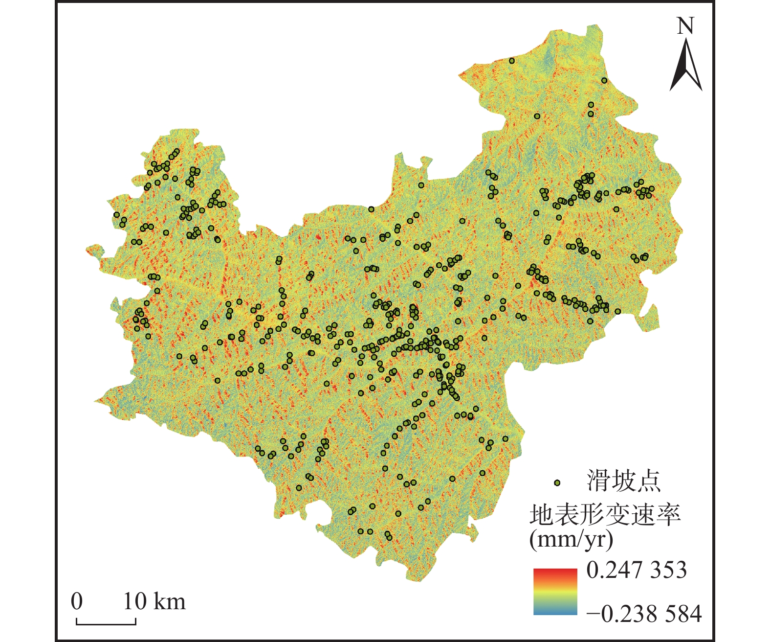
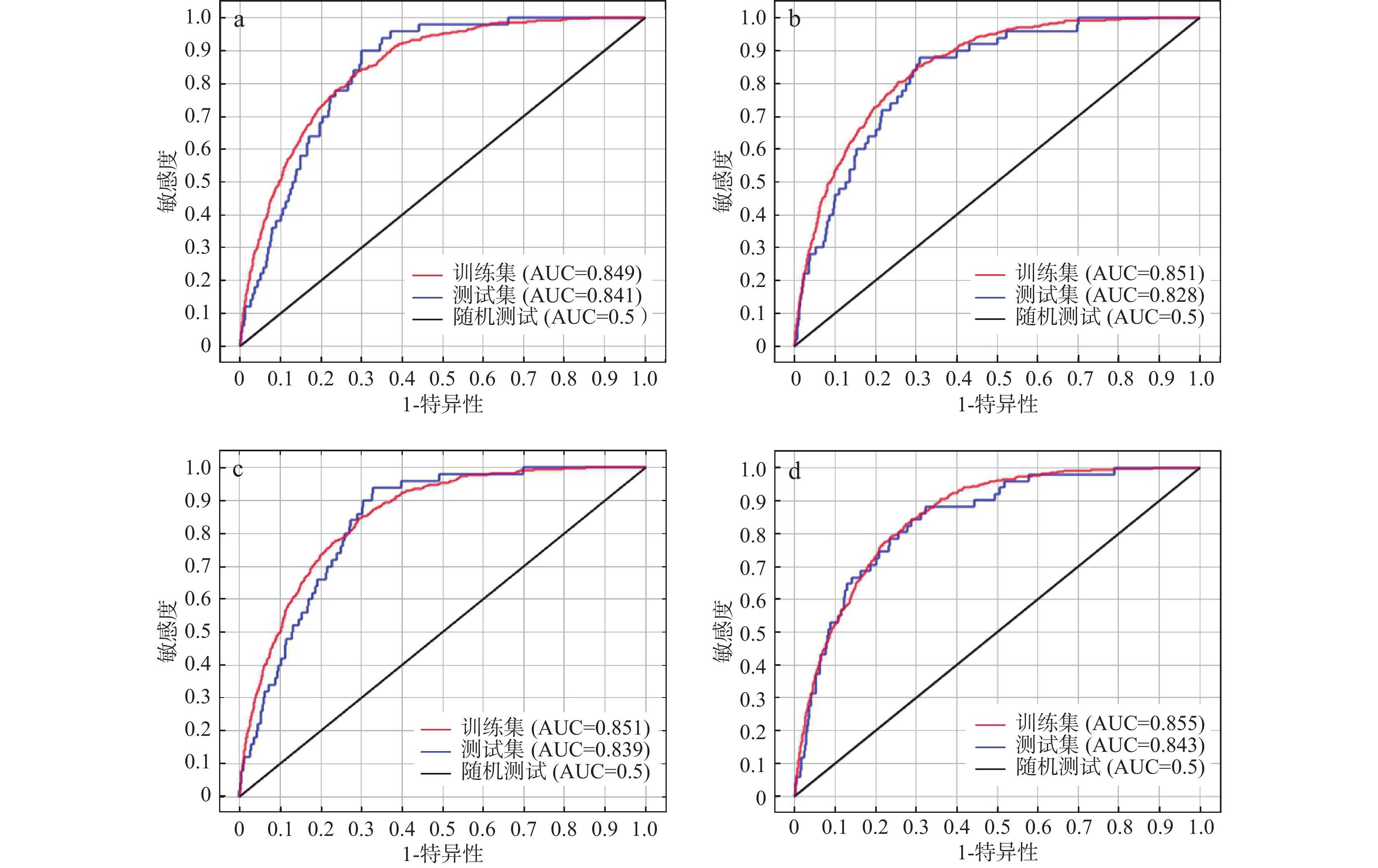
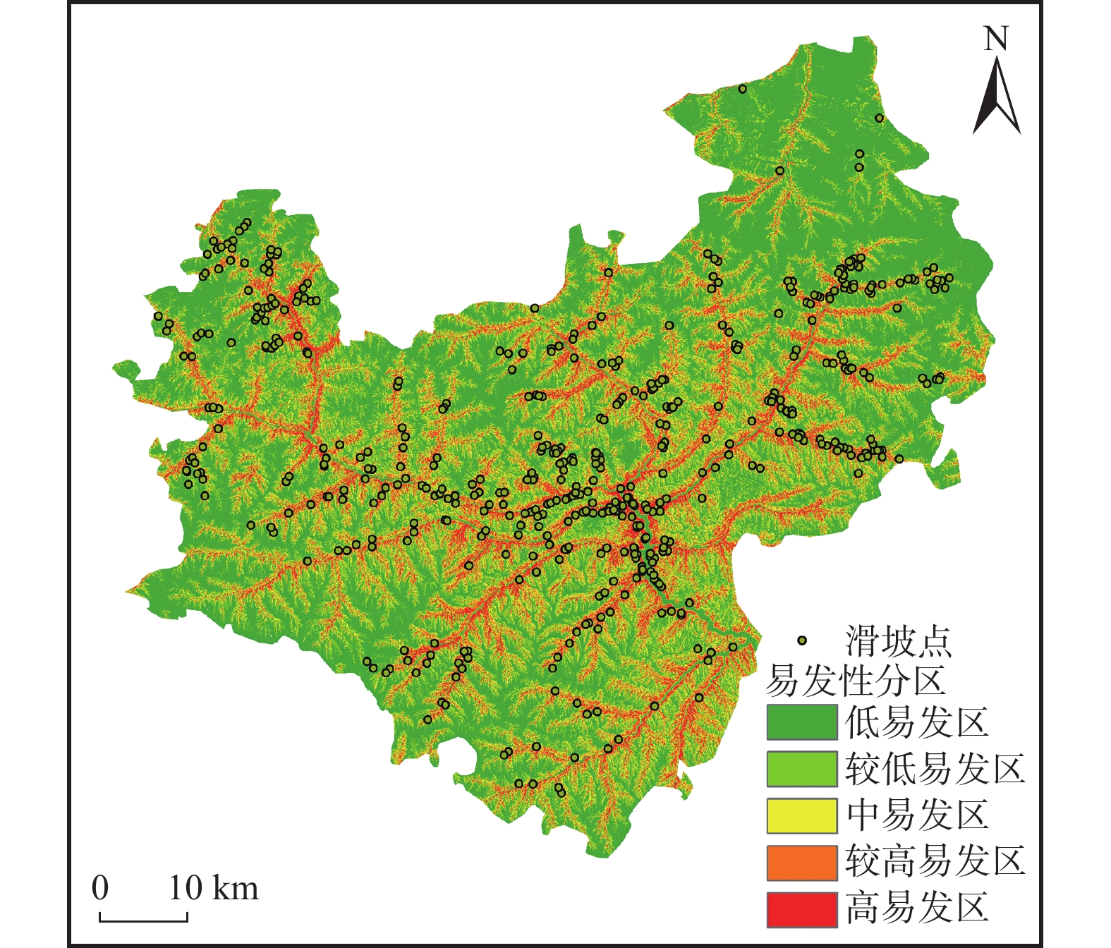
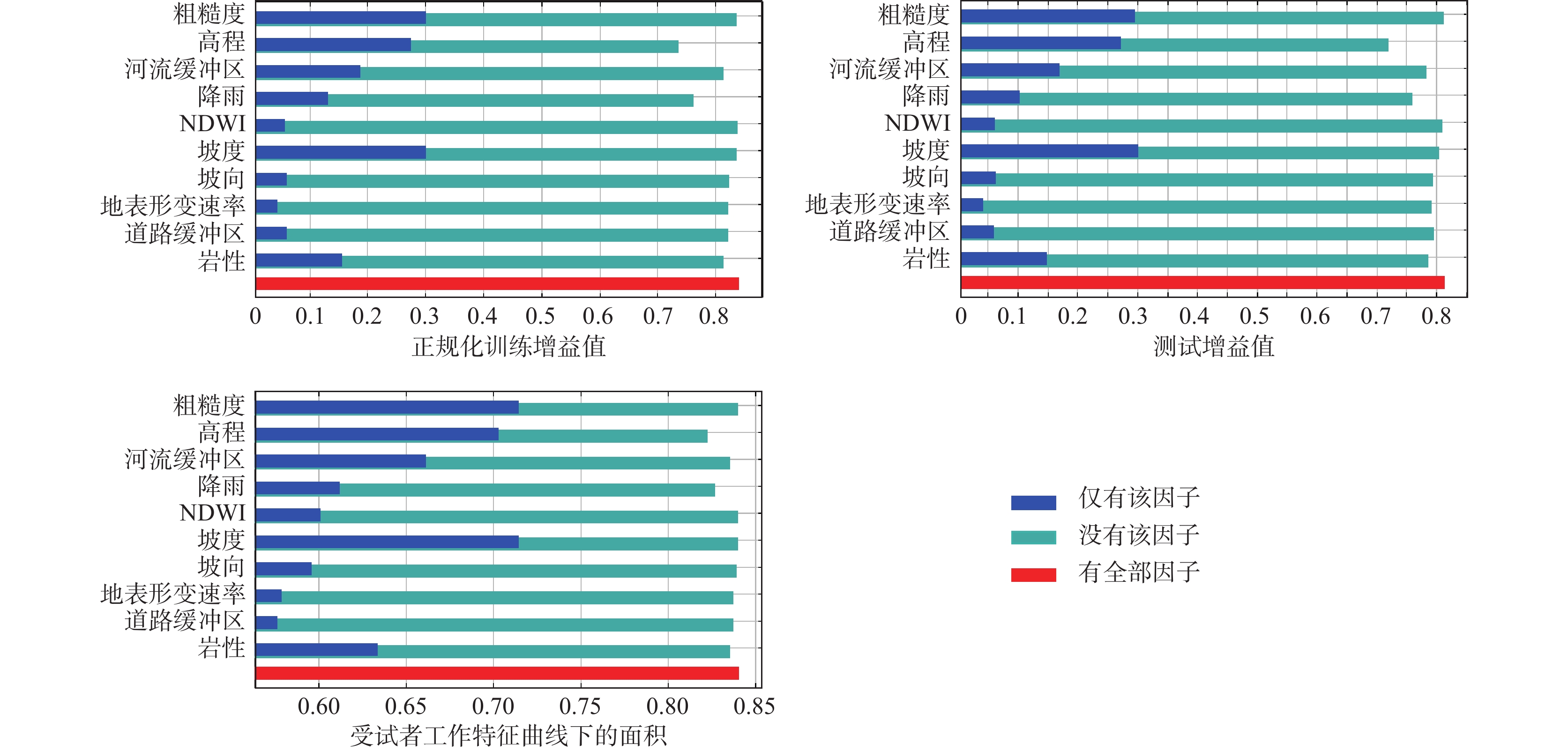
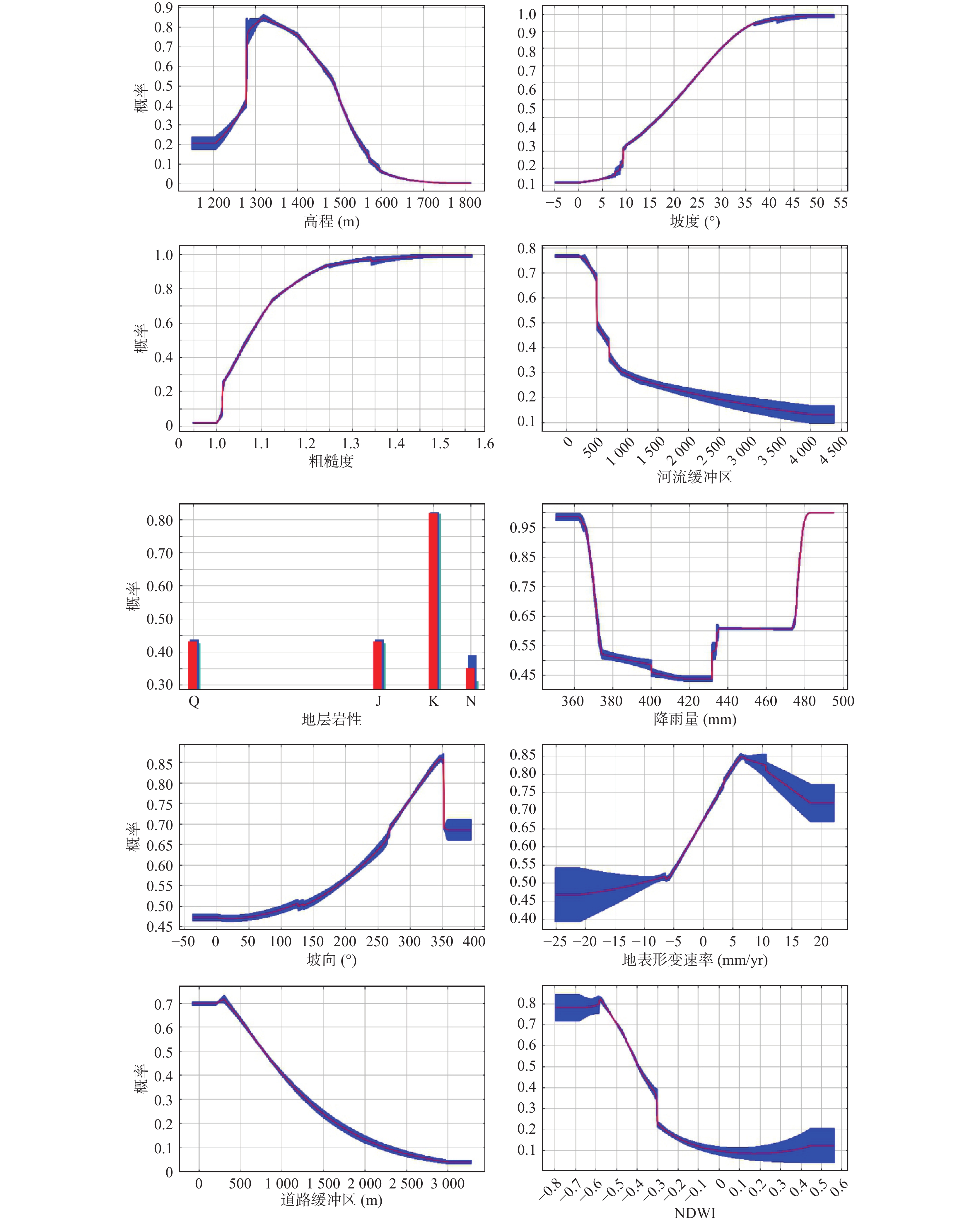
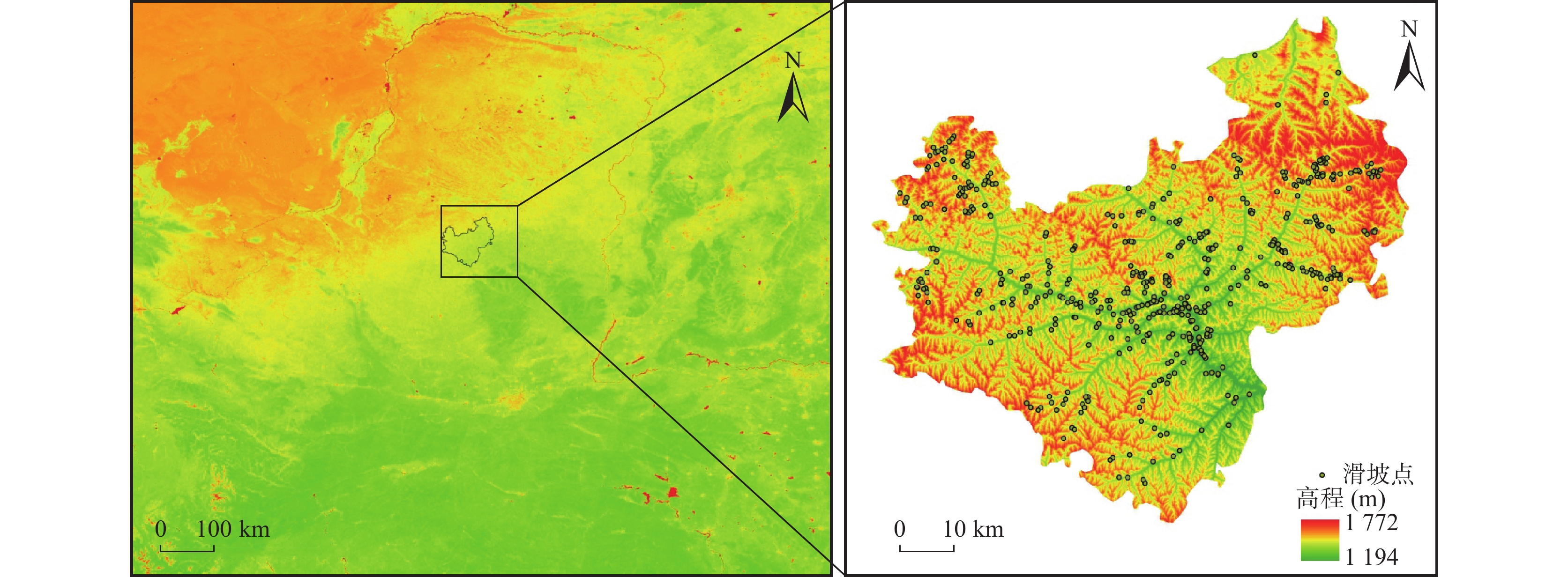
黄土高原地区滑坡灾害频发,严重危害人民生命财产安全和重大工程建设,进行精准的滑坡易发性评价,识别“什么地方易发生”,有助于高效预测滑坡灾害风险,为防灾减灾提供有效的科学依据。笔者以黄土高原腹地吴起县为例,采用优化最大熵模型(MaxEnt),利用505个滑坡点,选取高程、坡向、坡度、地形粗糙度、岩性、河流缓冲区、降雨、NDWI(地表湿度)及道路缓冲区作为评价因子,并引入InSAR地表形变数据作为动态评价因子,开展了滑坡易发性评价。基于Enmeval数据包调整优化的MaxEnt模型,分别随机选取90%和10%的滑坡点进行模型训练及验证,模型精度高(AUC值为0.855),模拟效果准确可信。引入InSAR地表形变速率作为动态评价因子,模型精度、评价结果均有所提升。评价结果显示:研究区较高易发区面积和高易发区面积分别占吴起县总面积10.27%和6.33%,高、较高易发区内的滑坡点占全部滑坡点的73.27%,滑坡易发性评价结果与滑坡点分布现状吻合,评价效果好。高程、坡度和地表粗糙度对模型模拟结果贡献较高,是研究区滑坡易发性重要评价因子。
-
关键词:
- 黄土地貌区 /
- 优化MaxEnt模型 /
- 黄土滑坡 /
- 易发性评价 /
- 吴起县
Abstract:Landslide disasters which occur frequently in the Loess Plateau, seriously endanger the safety of people's lives and property, and affect the construction of major projects. Accurate landslide susceptibility assessment is useful for efficiently and quickly landslide risk prediction, and can provide scientific backing for disaster prevention and reduction by identifying "where landslides are prone". Taking Wuqi County on the Loess Plateau as an example, we use the optimized MaxEnt model and 505 landslide points to evaluate the landslide susceptibility. Elevation, aspect, slope, terrain roughness, lithology, river buffer, rainfall, NDWI (surface humidity), road buffer, and InSAR surface deformation data, which was introduced as dynamic evaluation factors, were selected as influencing factors. The results show: In the MaxEnt model based on Enmeval packet adjustment, when 90% landslide points were randomly selected as the training set and 10% landslide points as the verification set, the model accuracy was the highest (AUC value was 0.855), and the simulation effect was accurate and reliable. InSAR surface deformation rate was introduced as a dynamic evaluation factor, and the model accuracy and evaluation results were both improved. In the study area, the area of high and relatively high susceptibility areas accounted for 10.27% and 6.33% of the total area respectively, and the landslide points in the high and relatively high prone areas accounted for 73.27% of the total landslide points, of which the high prone areas accounted for 48.11%. The evaluation results of landslide susceptibility were consistent with the distribution of landslide points, which proves that the evaluation works well. Elevation, slope and surface roughness contribute significantly to the simulation results, and are important factors affecting the landslide susceptibility.
-
Key words:
- loess landform region /
- optimized MaxEnt model /
- loess landslide /
- evaluation /
- Wuqi county
-

-
表 1 基于刀切法评价因子重要性分布表
Table 1. The importance distribution table of evaluation factors based on knife-cutting method
评价因子 贡献率(%) 坡度 38.4 岩性 18.6 高程 18.1 河流缓冲区 9.4 坡向 6.6 道路缓冲区 2.6 NDWI 2.3 地表粗糙度 1.6 地表形变速率 1.2 降雨 1.1 NDBI 0 NDVI 0 平面曲率 0 剖面曲率 0  下载: 导出CSV
表 2 不同参数设置下MaxEnt模型评价结果
Table 2. Evaluation results of MaxEnt model under different parameters setting
是否引入地表形变速率 模型评价 调控倍频 特征组合 Delta.AICc 10%训练遗漏率 引入地表形变速率 默认 1 LQHPT 13.0896 0.131827 优化 1.5 QHP 0 0.129843 未引入地表形变速率 默认 1 LQHPT 37.4817 0.126679 优化 0.5 QHP 0 0.115884
下载: 导出CSV
表 3 易发性评价结果与滑坡点分布现状对比
Table 3. Comparison of susceptibility evaluation results and landslide point distribution status
易发登记 面积(km2) 面积百分比(%) 滑坡点数量(个) 滑坡点占比 滑坡点密度 高易发区 241.96 6.33 243 48.11 1.01 较高易发区 392.90 10.27 127 25.15 0.32 中易发区 596.17 15.59 80 15.8 0.13 较低易发区 845.52 22.11 44 8.7 0.05 低易发区 1747.84 45.70 11 2.2 0.1 合计 3824.39 100% 505 100% /
下载: 导出CSV
表 4 各评价因子的贡献率和置换重要性比值表
Table 4. Contribution and inportance of impact variables affecting the landslide susceptibility
评价因子 因子贡献率(%) 置换重要性(%) 高程 25.2 33.9 坡度 20.1 24.2 粗糙度 14 11.3 河流缓冲区 11.7 7.3 岩性 11.3 4.1 降雨 7.1 7.9 坡向 5.1 2.2 地表变形速率 3.2 3.6 道路缓冲区 1.5 4.3 NDWI 0.7 1.1
下载: 导出CSV
-
[1] 陈舞, 王浩, 张国华, 等. 基于T-S模糊故障树和贝叶斯网络的隧道坍塌易发性评价[J]. 上海交通大学学报, 2020, 54(8): 820−830.
CHEN Wu, WANG Hao, ZHANG Guohua, et al. Evaluation of Tunnel Collapse Susceptibility Based on T-S Fuzzy Fault Tree and Bayesian Network[J]. Journal of Shanghai Jiaotong University,2020,54(8):820−830.
[2] 段钊, 赵法锁, 陈新建. 陕北黄土高原区滑坡发育类型与时空分布特征——以吴起县为例[J]. 灾害学, 2011, 26(4): 52−56.
DUAN Zhao, ZHAO Fasuo, CHEN Xinjian. Types and Spatio-Temporal Distribution of Loess Landslides in Loess Plateau Region —A Case Study in Wuqi County[J]. Journal of Catastrophology,2011,26(4):52−56.
[3] 郭飞, 赖鹏, 黄发明, 等. 基于知识图谱的滑坡易发性评价文献综述及研究进展[J]. 地球科学, 2024, 49(5): 1587−1606.
GUO Fei,LAI Peng,HUANG Faming,et al. Literature review and research progress of landslide susceptibility mapping based on knowledge graph[J]. Earth Science,2024,49(5):1587−1606.
[4] 高秉海, 何毅, 张立峰, 等. 顾及InSAR形变的CNN滑坡易发性动态评估——以刘家峡水库区域为例[J]. 岩石力学与工程学报, 2023, 42(2): 450−465.
GAO Binghai, HE Yi, ZHANG Lifeng, et al. Dynamic evaluation of landslide susceptibility by CNN considering InSAR deformation: A case study of Liujiaxia reservoir[J]. Chinese Journal of Rock Mechanics and Engineering,2023,42(2):450−465.
[5] 胡胜, 邱海军, 王宁练, 等. 地形对黄土高原滑坡的影响[J]. 地理学报, 2021, 76(11): 2697−2709.
HU Sheng, QIU Haijun, WANG Ninglian, et al. The influence of terrain on loess landslides in Loess Plateau[J]. Acta Geographica Sinica,2021,76(11):2697−2709.
[6] 贾丽娜, 陈世昌. 基于AHP和GIS的舟曲地质灾害易发性评价[J]. 西北地质, 2024, 57(1): 23−33.
JIA Lina,CHEN Shichang. Geological Hazard Susceptibility Evaluation Based on AHP and GIS in Zhouqu County, Gansu[J]. Northwestern Geology,2024,57(1):23−33.
[7] 胡燕, 李德营, 孟颂颂, 等. 基于证据权法的巴东县城滑坡灾害易发性评价[J]. 地质科技通报, 2020, 39(3): 187−194.
HU Yan, LI Deying, MENG Songsong, et al. Landslide susceptibility evaluation in Badong County based on weights of evidence method[J]. Bulletin of Geological Science and Technology,2020,39(3):187−194.
[8] 黄煜, 谢婉丽, 刘琦琦, 等. 基于GIS与MaxEnt模型的滑坡易发性评价——以铜川市中部城区为例[J]. 西北地质, 2023, 56(1): 266−275.
HUANG Yu, XIE Wanli, LIU Qiqi, et al. Landslide Susceptibility Assessment Based on GIS and MaxEnt Model: Example from Central Districts in Tongchuan City[J]. Northwestern Geology,2023,56(1):266−275.
[9] 姜建伟, 赵法锁, 祝俊华, 等. 陕西省吴起县斜坡几何形态与地质灾害相关性研究[J]. 灾害学, 2018, 33(2): 188−192.
JIANG Jianwei, ZHAO Fasuo, ZHU Junhua, et al. Study on the correlation between slope geometrical morphology and geological disasters in Wuqi County of Shaanxi Province[J]. Journal of Catastrophology,2018,33(2):188−192.
[10] 李泽芝, 王新刚. 镇域尺度下秦巴山区堆积层滑坡易发性不同单元评价性能对比研究[J]. 西北地质, 2024, 57(1): 1−11.
LI Zezhi,WANG Xingang. Comparative Study on Evaluation Performance of Different Units of Susceptibility of Accumulation Layer Landslide in Qinba Mountain Area at Town Scale[J]. Northwestern Geology,2024,57(1):1−11.
[11] 林琴, 郭永刚, 吴升杰, 等. 基于梯度提升的优化集成机器学习算法对滑坡易发性评价: 以雅鲁藏布江与尼洋河两岸为例[J]. 西北地质, 2024, 57(1): 12−22.
LIN Qin,GUO Yonggang,WU Shengjie,et al. Evaluation of Landslide Susceptibility by Optimization Integrated Machine Learning Algorithm Based on Gradient Boosting: Take Both Banks of Yarlung Zangbo River and Niyang River as Examples[J]. Northwestern Geology,2024,57(1):12−22.
[12] 刘东生, 安芷生, 文启忠, 等. 中国黄土的地质环境[J]. 科学通报, 1978(1): 19−26.
LIU Tongsheng, AN Zhisheng, WEN Qizhong, et al. Geological Environment of Chinese Loess[J]. Chinese Science Bulletin,1978(1):19−26.
[13] 兰恒星, 彭建兵, 祝艳波, 等. 黄河流域地质地表过程与重大灾害效应研究与展望[J]. 中国科学: 地球科学, 2022, 65(2): 234−256.
LAN Hengxing,PENG Jianbing,ZHU Yanbo,et al. Research on geological and surfacial processes and major disaster effects in the Yellow River Basin[J]. Science China Earth Sciences,2022,65(2):234−256.
[14] 麦鉴锋, 冼宇阳, 刘桂林. 气候变化情景下广东省降雨诱发型滑坡灾害潜在分布及预测[J]. 地球信息科学学报, 2021, 23(11): 2042−2054. doi: 10.12082/dqxxkx.2021.210182
MAI Jianfeng, XIAN Yuyang, LIU Guilin. Predicting Potential Rainfall-Triggered Landslides Sites in Guangdong Province (China) using MaxEnt Model under Climate Changes Scenarios[J]. Journal of Geo-information Science,2021,23(11):2042−2054. doi: 10.12082/dqxxkx.2021.210182
[15] 牛全福, 冯尊斌, 党星海, 等. 黄土区滑坡研究中地形因子的选取与适宜性分析[J]. 地球信息科学学报, 2017, 19(12): 1584−1592.
NIU Quanfu, FENG Zunbin, DANG Xinghai, et al. Suitability analysis of topographic factors in Loess landslide research[J]. Journal of Geo-information Science,2017,19(12):1584−1592.
[16] 彭建兵, 兰恒星, 钱会, 等. 宜居黄河科学构想[J]. 工程地质学报, 2020, 28(2): 189−201.
PENG Jianbing, LAN Hengxing, QIAN Hui, et al. Scientific research framework of livable Yellow River[J]. Journal of Engineering Geology,2020,28(2):189−201.
[17] 彭建兵, 王启耀, 门玉明, 等. 黄土高原滑坡灾害[M]. 北京: 科学出版社, 2019.
PENG Jianbing, WANG Qiyao, MEN Yuming, et al. Landslides in loess Plateau[M]. Beijing: Science Press, 2019.
[18] 孙萍萍, 张茂省, 贾俊, 等. 中国西部黄土区地质灾害调查研究进展[J]. 西北地质, 2022, 55(3): 96−107.
SUN Pingping, ZHANG Maosheng, JIA Jun, et al. Geo-hazards Research and Investigation in the Loess Regions of Western China[J]. Northwestern Geology,2022,55(3):96−107.
[19] 孙长明, 马润勇, 尚合欣等. 基于滑坡分类的西宁市滑坡易发性评价[J]. 水文地质工程地质, 2020, 47(3): 173−181.
SUN Changming, MA Runyong, SHANG Hexin, et al. Landslide susceptibility assessment in Xining based on landslide classification[J]. Hydrogeology & Engineering Geology,2020,47(3):173−181.
[20] 孙萍萍, 张茂省, 程秀娟, 等. 黄土高原地质灾害发生规律[J]. 山地学报, 2019, 37(5): 737−746.
SUN Pingping, ZHANG Maosheng, CHENG Xiujuan, et al. On the Regularity of Geological Hazards on the Loess Plateau in China[J]. Mountain Research,2019,37(5):737−746.
[21] 唐亚明, 张茂省, 李林, 等. 滑坡易发性危险性风险评价例析[J]. 水文地质工程地质, 2011, 38(2): 125−129.
TANG Yaming, ZHANG Maosheng, LI Lin, et al. Discrimination to the landslide susceptibility, hazard and risk assessment[J]. Hydrogeology & Engineering Geology,2011,38(2):125−129.
[22] 唐兴港, 王慧勇, 黄豆, 等. 长江中下游地区滑坡的易发性评价——以江西省为例[J]. 水土保持通报, 2021, 41(3): 166−172.
TANG Xinggang, WANG Huiyong, HUANG Dou, et al. Evaluation of Landslide Susceptibility in Middle and Lower Reaches of Yangtze River-Taking Jiangxi Province as a Caes Study[J]. Bulletin of Soiland Water Conservation,2021,41(3):166−172.
[23] 唐亚明, 程秀娟, 薛强, 等. 基于层次分析法的黄土滑塌风险评价指标权重分析[J]. 中国地质灾害与防治学报, 2012, 23(4): 40−46.
TANG Yaming, CHENG Xiujuan, XUE Qiang, et al. Weights analysis of loess collapse risk assessing factors based on analytical hierarchy process[J]. The Chinese Journal of Geological Hazard and Control,2012,23(4):40−46.
[24] 吴树仁, 石菊松, 张春山, 等. 地质灾害风险评估技术指南初论[J]. 地质通报, 2009, 28(8): 995−1005.
WU Shuren, SHI Jusong, ZHANG Chunshan, et al. Preliminary discussion on technical guideline for geohazard risk assessment[J]. Geological Bulletin of China,2009,28(8):995−1005.
[25] 王本栋, 李四全, 许万忠, 等. 基于3种不同机器学习算法的滑坡易发性评价对比研究[J]. 西北地质, 2024, 57(1): 34−43.
WANG Bendong,LI Siquan,XU Wanzhong,et al. A Comparative Study of Landslide Susceptibility Evaluation Based on Three Different Machine Learning Algorithms[J]. Northwestern Geology,2024,57(1):34−43.
[26] 王高峰, 郭宁, 邓兵, 等. 不同组合模型区域滑坡易发性及精度分析[J]. 西北地质, 2021, 54(2): 259−272.
WANG Gaofeng, GUO Ning, DENG Bing, et al. Analysis of Landslide Susceptibility and Accuracy in Different Combination Models[J]. Northwestern Geology,2021,54(2):259−272.
[27] 王晓帆, 段雨营, 金露露, 等. 基于优化的最大嫡模型预测中国高山栋组植物的历史、现状与未来分布变化[J]. 生态学报, 2023, 43(16): 6590−6604.
WANG Xiaofan, DUAN Yuying, JIN Lulu, et al. Prediction of historical, present and future distribution of Ouercus sect. Heterobalanus based on the optimized MaxEnt model in China[J]. Acta Ecologica Sinica,2023,43(16):6590−6604.
[28] 万洋, 郭捷, 马凤山, 等. 基于最大熵模型的中尼交通廊道滑坡易发性分析[J]. 中国地质灾害与防治学报, 2022, 33(2): 88−95.
WAN Yang, GUO Jie, MA Fengshan, et al. Landslide susceptibility assessment based on MaxEnt model of along Sino-Nepal traffic corridor[J]. The Chinese Journal of Geological Hazard and Control,2022,33(2):88−95.
[29] 熊小辉, 汪长林, 白永健, 等. 基于不同耦合模型的县域滑坡易发性评价对比分析——以四川普格县为例[J]. 中国地质灾害与防治学报, 2022, 33(4): 114−124.
XIONG Xiaohui, WANG Changlin, BAI Yongjian, et al. Comparison of landslide susceptibility assessment based on multiple hybrid models at county level: A case study for Puge County, Sichuan Province[J]. The Chinese Journal of Geological Hazard and Control,2022,33(4):114−124.
[30] 于开宁, 吴涛, 魏爱华, 等. 基于AHP-突变理论组合模型的地质灾害危险性评价——以河北平山县为例[J]. 中国地质灾害与防治学报, 2023, 34(2): 146−155.
YU Kaining, WU Tao, WEI Aihua, et al. Geological hazard assessment based on the models of AHP, catastrophe theory and their combination: A case study in Pingshan County of Heibei Province[J]. The Chinese Journal of Geological Hazard and Control,2023,34(2):146−155.
[31] 赵冬梅, 角媛梅, 邱应美, 等. 基于maxEnt模型的哈尼梯田核心区滑坡易发性评价[J]. 水土保持学报, 2020, 27(4): 392−399.
ZHAO Dongmei, JIAO Yuanmei, QIU Yingmei, et al. Assessment on Landslide Susceptibility of the Core Area of Hani Race Terraces Heritage Site Maximum Entropy Model[J]. Research of Soil and Water Conservation,2020,27(4):392−399.
[32] 张伟, 周松林, 尹仑. 基于优化 MaxEnt 模型的高山峡谷区地质灾害易发性评价—以云南省德钦县为例[J]. 灾害学, 2023, 38(2): 185−190.
ZHANG Wei,ZHOU Songlin,YIN Lun. Evaluation of Susceptibility to Geological Hazard in Alpine Canyon Area Based on Optimized MaxEnt Model: A Case Study in Deqin County,Yunnan Province[J]. Journal of Catastrophology,2023,38(2):185−190.
[33] 曾韬睿, 邬礼扬, 金必晶, 等. 基于stacking集成策略和SBAS-InSAR的滑坡动态易发性制图[J]. 岩石力学与工程学报, 2023, 42(9): 2266−2282.
ZENG Taorui, WU Liyang, JIN Bijing, et al. Landslide dynamic susceptibility mapping based on stacking ensemble strategy and SBAS-InSAR[J]. Chinese Journal of Rock Mechanics and Engineering,2023,42(9):2266−2282.
[34] 朱耿平, 乔慧捷. Maxent模型复杂度对物种潜在分布区预测的影响[J]. 生物多样性, 2016, 24(10): 1189−1196. doi: 10.17520/biods.2016265
ZHU Gengping, QIAO Huijie. Effect of the Maxent model’s complexity on the prediction of species potential distributions[J]. Biodiversity Science,2016,24(10):1189−1196. doi: 10.17520/biods.2016265
[35] 张茂省, 李同录. 黄土滑坡诱发因素及其形成机理研究[J]. 工程地质学报, 2011, 19(4): 530−540.
ZHANG Maosheng, LI Tonglu. Triggering factors and forming mechanism of loess landslide[J]. Journal of Engineering Geology,2011,19(4):530−540.
[36] Ayalew L, Yamagishi H. The application of GIS-based logistic regression for landslide susceptibility mapping in the Kakuda-Yahiko Mountains, Central Japan[J]. Geomorphology,2005,65(1/2):15−31.
[37] Berardino P, Fornaro G, Lanari R, et al. A new algorithm for surface deformation monitoring based on small baseline differential SAR interferograms[J]. Geoscience and Remote Sensing,2002,40(11):2375−2383. doi: 10.1109/TGRS.2002.803792
[38] Corominas J, Van W C J, Frattini P, et al. Recommendations for the Quantitative Analysis of Landslide Risk[J]. Bulletin of Engineering Geology and the Environment,2014,73(2):209−263.
[39] Calderon-Guevara W, Sanchez-Silva M, Nitescu B, et al. Comparative Review of Data-driven Landslide Susceptibility Models: Case Study in the Eastern Andes Mountain Range of Colombia[J]. Natural Hazards,2022,113:1105−1132. doi: 10.1007/s11069-022-05339-2
[40] Calvello M, Peduto D, Arena L. Combined use of statistical and DInSAR data analyses to define the state of activity of slow-moving landslides[J]. Landslides,2017,14(2):473−489. doi: 10.1007/s10346-016-0722-6
[41] Chao Zhou, Ying Cao, Xie Hu, et al. Enhanced dynamic landslide hazard mapping using MT-InSAR method in the Three Gorges Reservoir Area[J]. Landslides,2022,19:1585−1597. doi: 10.1007/s10346-021-01796-1
[42] Fell R, Corominas J, Bonnard C, et al. Guidelines for Landslide Susceptibility, Hazard and Risk Zoning for Land use Planning[J]. Engineering Geology,2008,102(3-4):85−98. doi: 10.1016/j.enggeo.2008.03.022
[43] Felicisimo Á M, Cuartero A, Remondo J, et al. Mapping landslide susceptibility with logistic regression, multiple adaptive regression splines, classification and regression trees, and maximum entropy methods: a comparative study[J]. Landslides,2013,10(2):175−189. doi: 10.1007/s10346-012-0320-1
[44] Huang Faming, Yao Chi, Liu Weiping, et al. Landslide susceptibility assessment in the Nantian area of China: a comparison of frequency ratio model and support vector machine[J]. Geomatics,2018,1(9):919−938.
[45] Hitoshi S, Daichi N, Hiroshi M. Comparison of landslide susceptibility based on a decision-tree model and actual landslide occurrence: The Akaishi Mountains, Japan[J]. Geomorphology,2009,109(3-4):108−121. doi: 10.1016/j.geomorph.2009.02.026
[46] Kornejady A, Ownegh M, Bahrem A. Landslide susceptibility assessment using maximum entropy model with two different data sampling methods[J]. Catena,2017,152:144−162. doi: 10.1016/j.catena.2017.01.010
[47] Lima P, Steger S, Glade T, et al. Literature review and bibliometric analysis on data-driven assessment of landslide susceptibility[J]. Journal of Mountain Science, 2022, 19(6): 1670-1698.
[48] Lee S, Ryu J H, Won J S, et al. Determination and application of the weights for landslide susceptibility mapping using an artificial neural network[J]. Engineering Geology,2004,71(3−4):289−302. doi: 10.1016/S0013-7952(03)00142-X
[49] Muscarella R, Galante P J, Soley-Guardia M, et al. ENMeval: An R package for conducting spatially independent evaluations and estimating optimal model complexity for Maxent ecological niche models[J]. Methods in Ecology & Evolution,2015,5(11):1198−1205.
[50] Piacentini D, Devoto S, Mantovani M, et al. Landslide susceptibility modeling assisted by Persistent Scatterers Interferometry(PSI): an example from the northwestern coast of Malta[J]. Natural Hazards,2015,78(1):681−697. doi: 10.1007/s11069-015-1740-8
[51] Phillips S J, Erson R P, Dudik M, et al. Opening the black box: an open-source release of Maxent[J]. Ecography,2017,40(7):887−893. doi: 10.1111/ecog.03049
[52] Steven J P, Robert P A, Robert E S. Maximum entropy modeling of species geographic distributions[J]. Ecological Modelling,2006,190(3):231−259.
[53] Tang Yaming, Feng Fan, Guo Zizheng, et al. Integrating principal component analysis with statistically-based models for analysis of causal factors and landslide susceptibility mapping: A comparative study from the Loess Plateau area in Shanxi (China)[J]. Journal of Cleaner Production,2020,277(20):124−159.
[54] Warren D L, Seifert S N. Ecological niche modeling in Maxent: the importance of model complexity and the performance of model selection criteria[J]. Ecological Applications,2011,21(2):335−342. doi: 10.1890/10-1171.1
[55] Xu Ling, Yan Dongdong, Zhao Tengyuan. Probabilistic evaluation of loess landslide impact using multivariate model[J]. Landslides,2021,18(3):1011−1023. doi: 10.1007/s10346-020-01521-4
[56] Yuan Meijiao, Dong Meizhao, Yin Pingding, et al. Performance evaluation for four GIS-based models purposed to predict and map landslide susceptibility: A case study at a World Heritage site in Southwest China-ScienceDirect[J]. Catena,2019,183:104−221.
[57] Yong Weili, Xian Minwang, Hang Mao. Influence of Human Activity on Landslide Susceptibility Development in the Three Gorges area[J]. Natural Hazards,2020,104:2115−2151. doi: 10.1007/s11069-020-04264-6
[58] Yikunoamlak G, Selemawi A, Esayas M, et al. Current and future predicting potential areas of Oxytenanthera abyssinica(A. Richard) using MaxEnt model under climate change in Northern Ethiopia[J]. Ecological Processes,2020,9(1):1−15. doi: 10.1186/s13717-019-0204-6
[59] Zhuang Jianqi, Peng Jianbing, Wang Gonghui, et al. Distribution and characteristics of landslide in Loess Plateau: a case study in Shaanxi Province[J]. Engineering Geology,2018,236(26):89−96.
-


图(8)
表(4)
计量
- 文章访问数: 73
- PDF下载数: 11
- 施引文献: 0