

Research on Mine Ecological Environment Monitoring Technology Based on Multi-source Remote Sensing Data: A Case Study in Northern Shaanxi Coal Base
-
摘要:
矿产资源的开发会对周边生态环境产生负面作用,影响当地居民的生产生活。相比传统的矿山生态环境地面监测手段,遥感技术具有宏观性、动态性和经济性等优势,其高波谱分辨率、高空间分辨率及高时间分辨率,能全方位动态反映矿山生态问题现状与发展趋势。陕北煤炭基地是中国重要的煤炭能源基地之一,本研究选择其中一座生产矿山作为研究区,综合运用光学遥感和雷达遥感技术,精准捕捉煤矿开采活动所诱发的地面塌陷、土地损毁以及地表水体、植被状况等区域要素特征;针对重点监测区,进一步引入无人机遥感技术,实现对地裂缝、不稳定边坡等局部要素的精细化监测与识别,系统构建了数据获取、数据处理、遥感解译、数据分析等全流程矿山生态环境遥感监测技术体系。研究结果表明,多源遥感技术凭借卓越的全局视野、宏观分析能力及强大的数据追溯性,在矿山生态环境监测领域展现出了无可替代的优势,应用成效显著。在此基础上,提出了未来矿山生态环境监测预警智能体系“多网融合+实时监测+智能作业+任务协同+全面感知+自主决策”的发展方向。
Abstract:The exploitation of mineral resources can have negative effects on the local ecological environment and the livelihoods of nearby residents. Remote sensing technology provides a more cost-effective and comprehensive approach to monitoring mine ecology compared to traditional ground-based methods. Its high spectral, spatial, and temporal resolution enables a comprehensive and dynamic reflection of the status and development trends of ecological issues in mines. The northern Shaanxi coal base is a significant coal energy base in China. This paper focused on a production mine, comprehensively utilized Optical Remote Sensing and Radar Remote Sensing technologies, we can accurately capture the characteristics of regional elements such as ground subsidence, land damage, as well as surface water and vegetation conditions induced by coal mining activities. For key monitoring areas, the Unmanned Aerial Vehicle (UAV) remote sensing technology further enables refined monitoring and identification of local elements such as ground fissures and unstable slopes. This has systematically established a comprehensive remote sensing monitoring technology system for mine ecological environment, encompassing data acquisition, data processing, remote sensing interpretation, and data analysis. Research results indicate that multi-source remote sensing technology, with its outstanding global perspective, macro-analysis capabilities, and robust data traceability, has demonstrated an irreplaceable advantage in the field of mine ecological environment monitoring, achieving remarkable application effects. According to the proposal, the future intelligent mine environmental monitoring and early warning system should be developed with a focus on “multi-network integration + real-time monitoring + intelligent operation + task collaboration + comprehensive perception + autonomous decision-making”.
-

-
表 1 遥感数据源一览表
Table 1. List of remote sensing data sources
数据类型 数据源 空间分辨率(m) 特点及用途 合成孔径雷达 Sentinel-1 5×20 全天候、全天时、空间覆盖连续,
用于监测地面塌陷范围及沉降量高分卫星遥感 GF-1 2 获取方便、成本低,GF-1主要用于监测植被状况,
GF-2用于监测地表水体、土地损毁范围和程度等GF-2 0.8 无人机遥感 1∶ 1000 航空摄影0.1 分辨率高,灵活机动,主要用于监测地裂缝、
崩塌、滑坡和不稳定边坡等点上要素 下载: 导出CSV
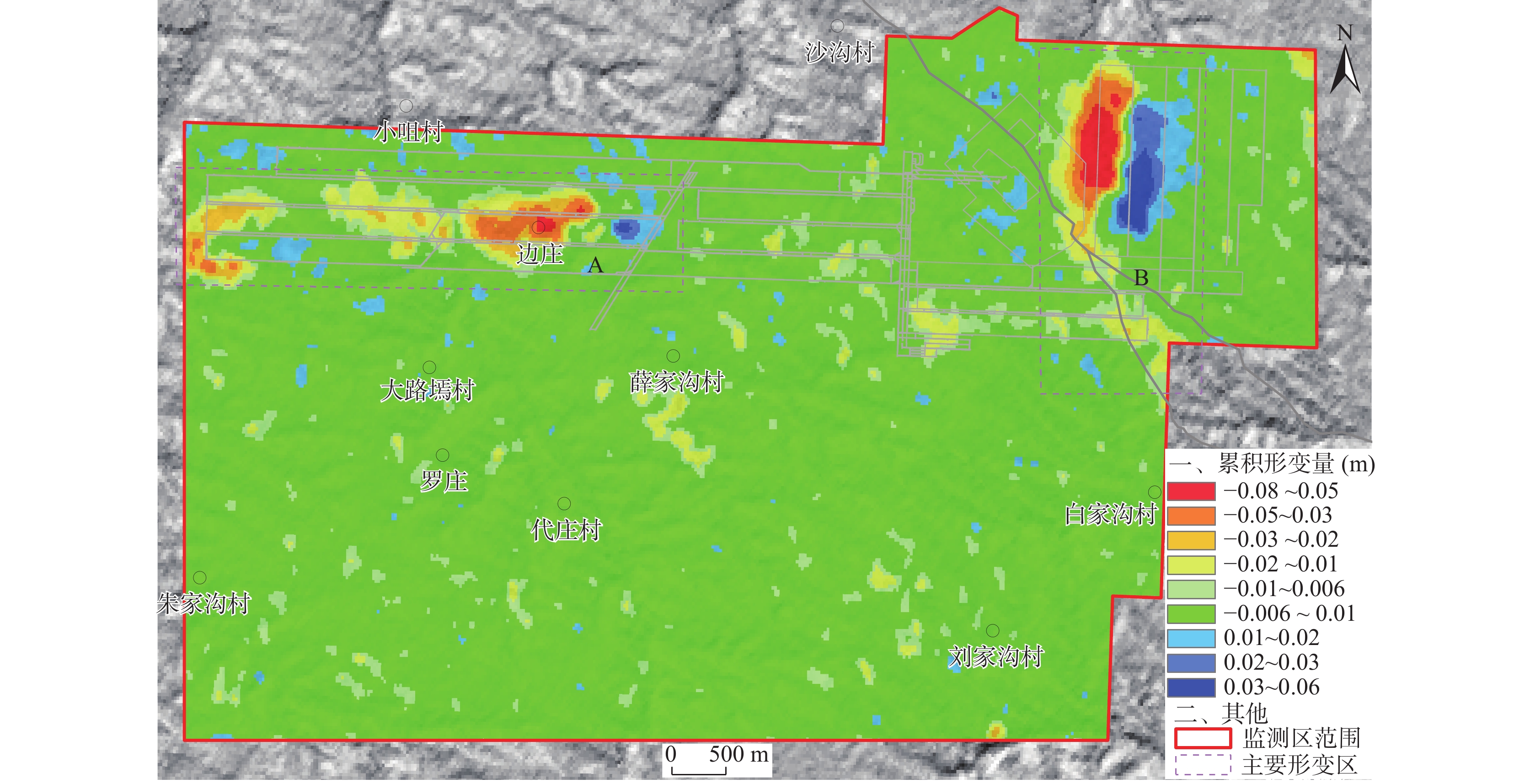
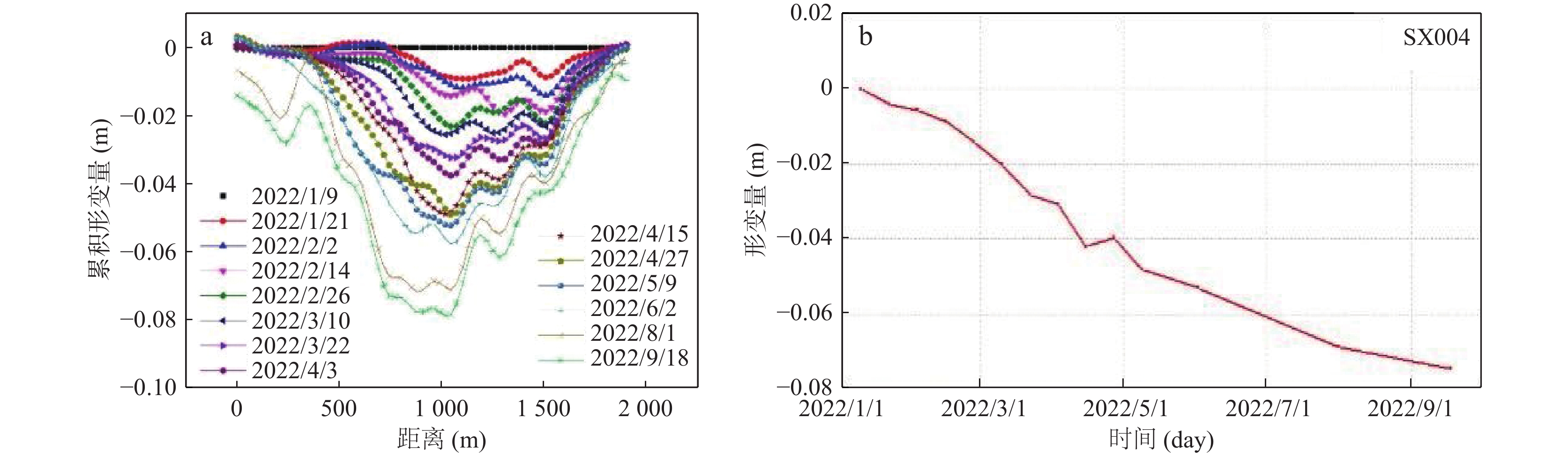
表 2 月度形变信息
Table 2. Monthly deformation information
月份 SAR成像时间 影像间隔时间(d) A区域最大
形变量(m)B区域最大
形变量(m)1 20220109_20220202 24 −0.025 −0.041 2 20220202_20220226 24 −0.030 −0.045 3 20220226_20220403 36 −0.039 −0.046 4 20220403_20220427 24 −0.031 −0.039 5 20220427_20220602 36 −0.059 −0.041 6~7 20220602_20220801 60 −0.030 −0.049 8~9 20220801_20220918 48 −0.044 −0.028
下载: 导出CSV
表 3 植被覆盖度分级统计情况
Table 3. Vegetation coverage classification statistics
序号 分级 植被覆盖度(%) 面积(hm2) 比例(%) 1 高覆盖度 ≥70 0.0126 0 2 较高覆盖度 50~70 1483.08 26.41 3 中等覆盖度 30~50 3913.307 69.70 4 较低覆盖度 10~30 1.4217 0.03 5 低覆盖度 <10 0.0215 0 建设用地、水体 216.9214 3.86 合计 5614.7642 100
下载: 导出CSV
-
[1] 陈国良, 时洪涛, 汪云甲, 等. 矿山地质环境“天—空—地—人”协同监测与多要素智能感知[J]. 金属矿山, 2023(1): 9−16.
CHEN Guoliang, SHI Hongtao, WANG Yunjia, et al. Integrated Space-Air-Ground-Human Monitoring and Multiple Parameters Intelligence Sensing of Mine Geological Environment[J]. Metal Mine,2023(1):9−16.
[2] 范立民. 论矿山地质环境监测体系[J]. 陕西地质, 2017, 35(1): 61−64. doi: 10.3969/j.issn.1001-6996.2017.01.012
FAN Limin. Monitoring System of Mining Geo-Environment[J]. Geology of Shaanxi,2017,35(1):61−64. doi: 10.3969/j.issn.1001-6996.2017.01.012
[3] 高俊华, 邹联学, 龙欢, 等. 基于遥感动态监测的吉林省矿山地质环境及生态修复变化特征分析[J]. 自然资源遥感, 2022, 34(3): 240−248.
GAO Junhua, ZOU Lianxue, LONG Huan, et al. Analysis on characteristics of mine geological environment and ecological restoration changes in Jilin Province based on dynamic remote sensing monitoring[J]. Remote Sensing for Natural Resources,2022,34(3):240−248.
[4] 黄登冕, 张聪, 姚晓军, 等. 矿山环境遥感监测研究进展[J]. 遥感技术与应用, 2022, 37(5): 1043−1055.
HUANG Dengmian, ZHANG Cong, YAO Xiaojun, et al. Research Progress of Mine Environment Remote Sensing Monitoring[J]. Remote Sensing Technology and Application,2022,37(5):1043−1055.
[5] 韩海辉, 王艺霖, 任广利, 等. 几种高光谱分析法在蚀变矿物信息提取中的对比分析——以北山老金厂为例[J]. 西北地质, 2020, 53(4): 223−234.
HAN Haihui, WANG Yilin, REN Guangli, et al. A Comparative Analysis of Several Hyperspectral Methods in the Extraction of Altered Minerals: A Case Study of Laojinchang in Beishan Area[J]. Northwestern Geology,2020,53(4):223−234.
[6] 韩海辉, 李健强, 易欢, 等. 遥感技术在西北地质调查中的应用及展望[J]. 西北地质, 2022a, 55(3): 155−169.
HAN Haihui, LI Jianqiang, YI Huan, et al. Application and Prospect of Remote Sensing Technology in Geological Survey of Northwest China[J]. Northwestern Geology,2022a,55(3):155−169.
[7] 韩海辉, 张转, 任广利, 等. 一种快速识别基性—超基性岩的新方法——基性度遥感指数法[J]. 西北地质, 2022b, 55(2): 71−81.
HAN Haihui, ZHANG Zhuan, REN Guangli, et al. A New Method for Fast Identification of Basic—ultrabasic Rocks—Basic Degree Index from Remote Sensing Image[J]. Northwestern Geology,2022b,55(2):71−81.
[8] 韩亚超, 高子弘, 杨达昌, 等. 我国城市水体数量与质量遥感调查应用现状与建议[J]. 城市地质, 2022, 17(4): 485−492. doi: 10.3969/j.issn.1007-1903.2022.04.013
HAN Yachao, GAO Zihong, YANG Dachang, et al. Review and suggestions of remote sensing survey of urban water bodies quantity and quality in our country[J]. Urban Geology,2022,17(4):485−492. doi: 10.3969/j.issn.1007-1903.2022.04.013
[9] 廉旭刚, 韩雨, 刘晓宇, 等. 无人机低空遥感矿山地质灾害监测研究进展及发展趋势[J]. 金属矿山, 2023(1): 17−29.
LIAN Xugang, HAN Yu, LIU Xiaoyu, et al. Study Progress and Development Trend of Mine Geological Disaster Monitoring by UAV Low-altitude Remote Sensing[J]. Metal Mine,2023(1):17−29.
[10] 蔺楠, 陈莹, 马露, 等. 陕北煤炭基地矿山生态修复成效评估体系构建与实现[J]. 西北地质, 2023, 56(3): 89−97. doi: 10.12401/j.nwg.2023085
LIN Nan, CHEN Ying, MA Lu, et al. Construction and Implementation of Evaluation System for Ecological Restoration Effectiveness of Mines in Northern Shaanxi Coal Base[J]. Northwestern Geology,2023,56(3):89−97. doi: 10.12401/j.nwg.2023085
[11] 李诗雨. 基于长时序InSAR的金属矿山地表形变监测技术研究[D]. 重庆: 重庆大学, 2022.
LI Shiyu. Research on Surface Deformation Monitoring Technology of Metal Mines based on Long-Time-Series InSAR[D]. Chongqing:Chongqing University, 2022.
[12] 苗旭, 李九一, 宋小燕等. 2000-2020年鄂尔多斯市植被NDVI变化格局及归因分析[J]. 水土保持研究, 2022, 29(3): 300−305. doi: 10.3969/j.issn.1005-3409.2022.3.stbcyj202203040
MIAO Xu, LI Jiuyi, SONG Xiaoyan, et al. Analysi on Change Pattern and Attribution of Vegetation NDVI in Ordos City from 2000 to 2020[J]. Research of Soil and Water Conservation,2022,29(3):300−305. doi: 10.3969/j.issn.1005-3409.2022.3.stbcyj202203040
[13] 王凤娟. 论遥感影像在矿山地质环境监测治理方面的应用[J]. 世界有色金属, 2020(12): 264−265. doi: 10.3969/j.issn.1002-5065.2020.12.121
WANG Fengjuan. Discussion on the application of remote sensing image in mine geological environment monitoring and treatment[J]. World Nonferrous Metals,2020(12):264−265. doi: 10.3969/j.issn.1002-5065.2020.12.121
[14] 吴松. 无人机航空摄影测量在矿山动态监测中的应用[J]. 能源与节能, 2023(2): 173−176. doi: 10.3969/j.issn.2095-0802.2023.02.047
WU Song. Application of UAV Aerial Photogrammetry in Mine Dynamic Monitoring[J]. Energy and Energy Conservation,2023(2):173−176. doi: 10.3969/j.issn.2095-0802.2023.02.047
[15] 徐友宁, 武征, 赵子长. 西北地区矿产资源开发的环境地质问题及其类型[J]. 西北地质, 2001, 34(2): 28−33. doi: 10.3969/j.issn.1009-6248.2001.02.005
XU Youning, WU Zheng, ZHAO Zichang. The Problems of Environmental Geology and Database for Mining in Northwestern China[J]. Northwestern Geology,2001,34(2):28−33. doi: 10.3969/j.issn.1009-6248.2001.02.005
[16] 徐友宁. 矿山环境地质与地质环境[J]. 西北地质, 2005, 38(4): 108−112. doi: 10.3969/j.issn.1009-6248.2005.04.016
XU Youning. Mine Environmental geology and geological environment[J]. Northwestern Geology,2005,38(4):108−112. doi: 10.3969/j.issn.1009-6248.2005.04.016
[17] 徐友宁, 李玉武, 张江华, 等. 宁夏石嘴山采煤塌陷区地质环境治理模式研究[J]. 西北地质, 2015, 48(4): 183−189. doi: 10.3969/j.issn.1009-6248.2015.04.018
XU Youning, LI Yuwu, ZHANG Jianghua, et al. Treatment Model on Geo-Environment in the Coal Mine Collapse Area of Shizuishan City, Ningxia[J]. Northwestern Geology,2015,48(4):183−189. doi: 10.3969/j.issn.1009-6248.2015.04.018
[18] 徐友宁, 张江华, 何芳, 等. 西北地区矿山地质环境调查与防治研究[J]. 西北地质, 2022, 55(3): 129−139.
XU Youning, ZHANG Jianghua, HE Fang, et al. Investigation and Preventive Research of Mine Geological Environment in Northwest China[J]. Northwestern Geology,2022,55(3):129−139.
[19] 杨金中, 聂洪峰, 荆青青. 初论全国矿山地质环境现状与存在问题[J]. 国土资源遥感, 2017, 29(2): 1−7.
YANG Jinzhong, NIE Hongfeng, JING Qingqing. Preliminary analysis of mine geo-environment status and existing problems in China[J]. Remote Sensing for Land and Resources,2017,29(2):1−7.
[20] 郑志琴. 基于D-InSAR技术的矿区地表沉陷监测及其数据处理研究[D]. 西安: 西安科技大学, 2015.
ZHENG Zhiqin. Surface Subsidence Monitoring and Data Processing Research of Mining Area Based on D-InSAR Technology[D]. Xi’an: Xi’an University of Science and Technology, 2015.
[21] Chen W, Li X, He H. A review of fine-scale land use and land cover classification in open-pit mining areas by re-mote sensing techniques[J]. Remote Sensing,2017,10(2):10010015−10010033.
[22] Gallwey J, Robiati C, Coggan J, et al. A Sentinel-2 based multispectral convolutional neural network for detecting arti-sanal small-scale mining in Ghana: Applying deep learning toshallow mining[J]. Remote Sensing of Environment,2020,248:111970−111984. doi: 10.1016/j.rse.2020.111970
[23] Johansen K, Erskine P, Mccabe M. Using unmanned aerial vehicles to assess the rehabilitation performance of open cut coal mines[J]. Journal of Cleaner Production,2019,209:819−833. doi: 10.1016/j.jclepro.2018.10.287
[24] Li L, Zhang R, Sun J, et al. Monitoring and prediction of dust concentration in an open-pit mine using a deep-learning algorithm[J]. Journal of Environmental Health Science and Engineering,2021,19(1):401−414. doi: 10.1007/s40201-021-00613-0
-


图(12)
表(3)
计量
- 文章访问数: 445
- PDF下载数: 61
- 施引文献: 0