

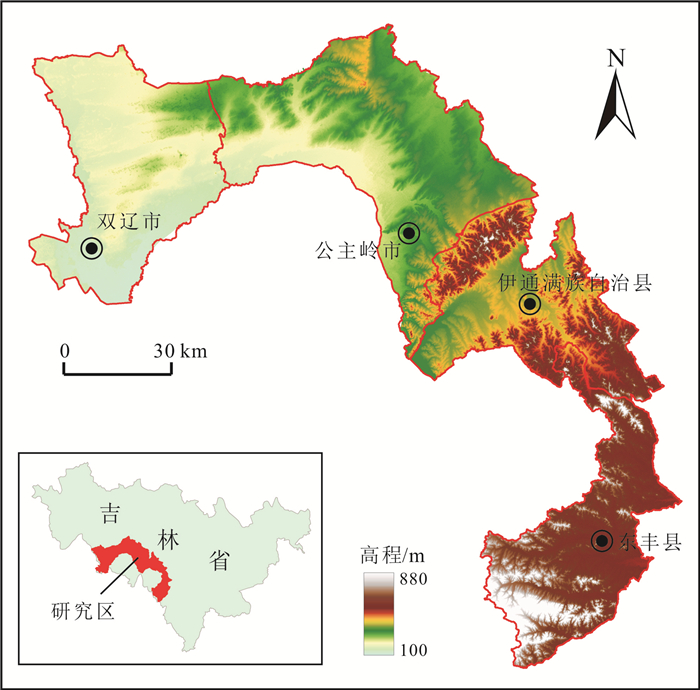
SUITABILITY EVALUATION OF GROUND SUBSTRATE BASED ON AHP-GIS: A Case Study of Shuangliao-Dongfeng Region in Jilin Province
-
摘要:
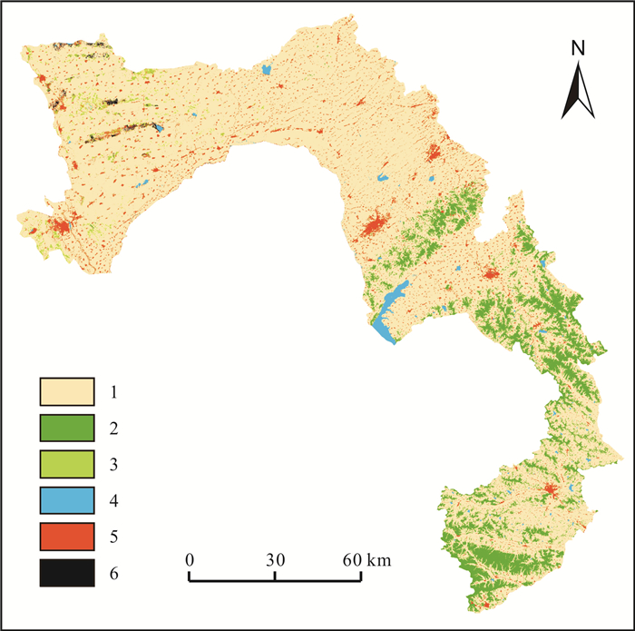
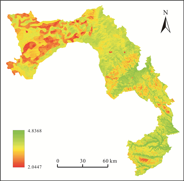
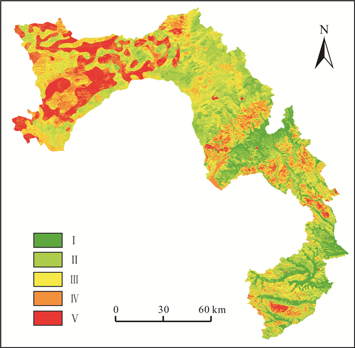
以双辽-东丰地区为研究对象, 利用GIS空间分析和层次分析法(AHP), 评价地表基质是否适宜支撑该地区的林地、草地、耕地等土地利用类型. 选取地形、地表基质物理特征、化学特征、气候特征等4个方面共12项指标, 构建地表基质适宜性评价模型. 评价结果表明: 区域内地表基质适宜性整体良好, Ⅰ、Ⅱ级区域总面积为5 072.78 km2, 占比41.55%, 主要分布于研究区中部平原地区和东南部沟谷地区; Ⅲ级区域总面积为3 609.91 km2, 占比29.57%, 呈零星状分布于研究区全域; Ⅳ、Ⅴ级区域总面积为3 525.84 km2, 占比28.88%, 集中分布于研究区西部平原地区, 分布东南部丘陵地区. 与传统土地利用适宜性评价相比, 此评价嵌入了地表基质相关指标, 以期为地表基质调查服务支撑国土空间综合利用找寻突破点, 为地表基质适宜性评价下一步工作提供思路.
Abstract:Taking Shuangliao-Dongfeng region as the study object, the GIS spatial analysis and analytic hierarchy process(AHP) are used to evaluate whether the ground substrate is suitable for the land use types such as forest land, grassland and cultivated land in the region. The evaluation model of ground substrate suitability is constructed with 12 indexes from 4 aspects including terrain, physical and chemical properties of ground substrate, and climate characteristics. The evaluation results show that the overall suitability of ground substrate in the region is good, and the total area of Grade I and II is 5 072.78 km2, accounting for 41.55%, mainly distributed in the central plain and southeastern gully area. The total area of Grade III is 3 609.91 km2, accounting for 29.57%, distributed sporadically throughout the study area. The total area of Grade IV and V is 3 525.84 km2, accounting for 28.88%, concentrated in the western plain area, with minors distributed in the southeastern hilly area. Compared with the traditional evaluation of land use suitability, the evaluation of this study embeds the related indicators of ground substrate to seek a breakthrough for the comprehensive utilization of land space by ground substrate survey and provide ideas for the following work of ground substrate suitability evaluation.
-
Key words:
- ground substrate /
- AHP /
- GIS /
- suitability evaluation /
- Jilin Province
-

-
表 1 地表基质适宜性评价因子权重
Table 1. Factor weight of ground substrate suitability evaluation
目标层 准则层 准则层权重 指标层 指标层权重 指标层对总目标层的权重 地表基质适宜性评价 地形 0.3765 坡度 0.6491 0.2444 坡向 0.2790 0.1050 高程 0.0719 0.0271 地表基质物理特征 0.3946 质地 0.2632 0.1038 有效土层厚度 0.0573 0.0226 垂向结构 0.5017 0.1980 容重 0.1778 0.0702 地表基质化学特征 0.1556 有机质含量 0.5278 0.0821 全碳 0.3325 0.0517 pH值 0.1396 0.0217 气候 0.0733 降水 0.8333 0.0611 气温 0.1667 0.0122 量化分值 5 4 3 2 1 地形 坡度/(°) < 5 5~10 10~15 15~20 > 20 坡向/(°) S (157.5~202.5) SW/SE (112.5~157.5/202.5~247.5) W/E (67.5~112.5/247.5~292.5) NW/NE (22.5~67.5/292.5~337.5) N (337.5~22.5) 高程/m 归一化处理, 高程越小越适宜 地表基质物理特征 质地 壤土 壤质黏土/黏质壤土 黏土/砂质壤土 砂质黏土/壤质砂土 砂土/粗骨土/岩石/砾质 垂向结构 壤土-黏土/壤土-壤土 黏土-壤土/砂土-壤土/壤土-砂土 壤土-岩石/砂土-黏土/砂土-壤土 黏土-岩石/砂土-岩石/砂土-砂土 粗骨土-粗骨土/粗骨土-岩石 容重 1.1~1.3 1.0~1.1/ 1.3~1.4 0.9~1.0/ 1.4~1.5 0.8~0.9/ 1.5~1.6 < 0.8/ > 1.6 有效土层厚度/cm 归一化处理, 有机质含量越高越适宜 地表基质化学特征 有机质含量/10-3 归一化处理, 有机质含量越高越适宜 pH值 6.5~7.0 6.0~6.5/ 7~7.5 5.0~6.0/ 7.5~8.5 4.5~5.0/ 8.5~9.0 < 4.5/ > 9.0 全碳/% 归一化处理, 全碳含量越高越适宜 气候 降水/mm 归一化处理, 降水越大越适宜 气温/℃ 归一化处理, 气温越高越适宜  下载: 导出CSV
表 2 地表基质适宜性因子量化标准
Table 2. Factor quantification criteria of ground substrate suitability evaluation
量化分值 5 4 3 2 1 地形 坡度/(°) < 5 5~10 10~15 15~20 >20 坡向/(°) S(157.5~202.5) SW/SE(112.5~157.5/202.5~247.5) W/E(67.5~112.5/247.5~292.5) NW/NE(22.5~67.5/292.5~337.5) N(337.5~22.5) 高程/m 归一化处理,高程越小越适宜 地表基质物理特征 质地 壤土 壤质黏土/黏质壤土 黏土/砂质壤土 砂质黏土/壤质砂土 砂土/粗骨土/岩石/砾质 垂向结构 壤土-黏土/壤土-壤土 黏土-壤土/砂土-壤土/壤土-砂土 壤土-岩石/砂土-黏土/砂土-壤土 黏土-岩石/砂土-岩石/砂土-砂土 粗骨土-粗骨土/粗骨土-岩石 容重 1.1~1.3 1.0~1.1/ 1.3~1.4 0.9~1.0/ 1.4~1.5 0.8~0.9/ 1.5~1.6 <0.8/>1.6 有效土层厚度/cm 归一化处理,有机质含量越高越适宜 地表基质化学特征 有机质含量/10-3 归一化处理,有机质含量越高越适宜 pH值 6.5~7.0 6.0~6.5/ 7~7.5 5.0~6.0/ 7.5~8.5 4.5~5.0/ 8.5~9.0 <4.5/>9.0 全碳/% 归一化处理,全碳含量越高越适宜 气候 降水/mm 归一化处理,降水越大越适宜 气温/℃ 归一化处理,气温越高越适宜
下载: 导出CSV
表 3 双辽-东丰地区各土地利用面积
Table 3. Areas of various land use types in Shuangliao-Dongfeng region
土地利用/覆盖类型 面积/km2 占比/% 耕地 8322.34 67.57 林地 2291.64 18.61 草地 219.59 1.78 水体 276.02 2.24 建设用地 937.75 7.61 裸地 269.03 2.18
下载: 导出CSV
表 4 双辽-东丰地区地表基质适宜性综合评价分级标准
Table 4. Grading criteria of ground substrate suitability evaluation in Shuangliao-Dongfeng region
评价等级 等级说明 阈值划分 Ⅴ-待保护用地 地表基质物理及化学特征、地形特征、气候特征等各项因子得分均较低,已不适宜各种植被生长,应采取保护措施 2.0447~3.2143 Ⅳ-仅适宜草地 大多数因子得分均较低,已不适合耕地或林地等条件限制相对较多的用地,可种植草地缓慢恢复生态环境 3.2143~3.5381 Ⅲ-适宜林草等生态用地 少数因子得分低,对生产用地农作物生长已产生限制,适宜林地、草地等生长需求条件较低的生态用地 3.5381~3.8034 Ⅱ-基本适宜所有类型用地 大多数因子得分较高,只有个别因子得分相对较低,基本适宜各种用地类型需求 3.8034~4.0757 Ⅰ-适宜所有类型用地 地表基质物理及化学特征、地形特征、气候特征等各项因子得分均较高,适合各种用地类型需求 4.0757~4.8368
下载: 导出CSV
表 5 双辽-东丰地区地表基质适宜性分析结果
Table 5. Analysis result of ground substrate suitability in Shuangliao-Dongfeng region
评价等级 面积/km2 占总面积比例/% Ⅴ-待保护用地 1326.70 10.87 Ⅳ-仅适宜草地 2199.14 18.01 Ⅲ-适宜林草等生态用地 3609.91 29.57 Ⅱ-基本适宜所有类型用地 3520.043 28.83 Ⅰ-适宜所有类型用地 1552.74 12.72
下载: 导出CSV
-
[1] 自然资源部. 自然资源部关于印发《自然资源调查监测体系构建总体方案》的通知[EB/OL].
https://www.gov.cn/zhengce/zhengceku/2020-01/18/content_5470398.htm , 2020-01-17.Ministry of Natural Resources of the People's Republic of China. Notice of the Ministry of Natural Resources on the issuance of The Overall Plan for the Construction of the Natural Resources Survey and Monitoring System[EB/OL].
https://www.gov.cn/zhengce/zhengceku/2020-01/18/content_5470398.htm , 2020-01-17. (in Chinese)[2] 葛良胜, 杨贵才. 自然资源调查监测工作新领域: 地表基质调查[J]. 中国国土资源经济, 2020, 33(9): 4-11, 67.
Ge L S, Yang G C. New field of natural resources survey and monitoring: Ground substrate survey[J]. Natural Resource Economics of China, 2020, 33(9): 4-11, 67.
[3] 王子垚. 中国土地适宜性评价研究进展[J]. 农业与技术, 2020, 40(4): 36-41.
Wang Z Y. Research progress of land suitability evaluation in China[J]. Agriculture and Technology, 2020, 40(4): 36-41. (in Chinese)
[4] 侯红星, 葛良胜, 孙肖, 等. 地表基质在中国黑土地资源调查评价中的应用探讨——基于黑龙江宝清地区地表基质调查[J]. 自然资源学报, 2022, 37(9): 2264-2276.
Hou H X, Ge L S, Sun X, et al. A study on the application of ground substrate in the survey and evaluation of China's black soil resources: Based on ground substrate survey in Baoqing, Heilongjiang Province[J]. Journal of Natural Resources, 2022, 37(9): 2264-2276.
[5] Bhagat R M, Singh S, Sood C, et al. Land suitability analysis for cereal production in Himachal Pradesh (India) using geographical information system[J]. Journal of the Indian Society of Remote Sensing, 2009, 37(2): 233-240. doi: 10.1007/s12524-009-0018-6
[6] 申世广, 王浩, 荚德平, 等. 基于GIS的常州市绿地适宜性评价方法研究[J]. 南京林业大学学报(自然科学版), 2009, 33(4): 72-76. doi: 10.3969/j.issn.1000-2006.2009.04.015
Shen S G, Wang H, Jia D P, et al. Land suitability evaluation methods for urban green space system planning based on GIS in Changzhou City[J]. Journal of Nanjing Forestry University (Natural Science Edition), 2009, 33(4): 72-76. doi: 10.3969/j.issn.1000-2006.2009.04.015
[7] Holzkämper A, Calanca P, Fuhrer J. Identifying climatic limitations to grain maize yield potentials using a suitability evaluation approach[J]. Agricultural and Forest Meteorology, 2013, 168: 149-159. doi: 10.1016/j.agrformet.2012.09.004
[8] Mendas A, Delali A. Integration of multicriteria decision analysis in GIS to develop land suitability for agriculture: Application to durum wheat cultivation in the region of Mleta in Algeria[J]. Computers and Electronics in Agriculture, 2012, 83: 117-126. doi: 10.1016/j.compag.2012.02.003
[9] Sarkar A, Ghosh A, Banik P. Multi-criteria land evaluation for suitability analysis of wheat: A case study of a watershed in eastern plateau region, India[J]. Geo-Spatial Information Science, 2014, 17(2): 119-128. doi: 10.1080/10095020.2013.774106
[10] Dengiz O. Land suitability assessment for rice cultivation based on GIS modeling[J]. Turkish Journal of Agriculture and Forestry, 2013, 37(3): 326-334.
[11] 韩慧杰, 夏学齐, 吴海东, 等. 基于GIS和土地质量地球化学数据的水稻种植适宜性评价——以安徽省青阳县为例[J]. 中国生态农业学报(中英文), 2019, 27(4): 591-600.
Han H J, Xia X Q, Wu H D, et al. Evaluation of rice planting suitability using GIS and geochemical land quality data: A case study of Qingyang County, Anhui Province[J]. Chinese Journal of Eco-Agriculture, 2019, 27(4): 591-600.
[12] 邱炳文, 池天河, 王钦敏, 等. GIS在土地适宜性评价中的应用与展望[J]. 地理与地理信息科学, 2004, 20(5): 20-23, 44. doi: 10.3969/j.issn.1672-0504.2004.05.005
Qiu B W, Chi T H, Wang Q M, et al. Application of GIS and its prospect in land suitability assessment[J]. Geography and Geo-Information Science, 2004, 20(5): 20-23, 44. doi: 10.3969/j.issn.1672-0504.2004.05.005
[13] 林燕, 白秀佳, 叶泽宇, 等. 基于ArcGIS的南通市农业生产适宜性评价[J]. 地质通报, 2021, 40(6): 968-977.
Lin Y, Bai X J, Ye Z Y, et al. Assessment of agricultural production suitability in Nantong City based on ArcGIS technology[J]. Geological Bulletin of China, 2021, 40(6): 968-977.
[14] 吴兆萍, 吴振宇, 黄涛. 基于遥感和GIS的彭阳县土地适宜性评价[J]. 宁夏工程技术, 2020, 19(2): 163-167, 172. doi: 10.3969/j.issn.1671-7244.2020.02.015
Wu Z P, Wu Z Y, Huang T. Land suitability evaluation of Pengyang County based on remote sensing and GIS[J]. Ningxia Engineering Technology, 2020, 19(2): 163-167, 172. doi: 10.3969/j.issn.1671-7244.2020.02.015
[15] 张炳江. 层次分析法及其应用案例[M]. 北京: 电子工业出版社, 2014.
Zhang B J. Hierarchical analysis and its application cases[M]. Beijing: Publishing House of Electronics Industry, 2014. (in Chinese)
[16] 唐常春, 孙威. 长江流域国土空间开发适宜性综合评价[J]. 地理学报, 2012, 67(12): 1587-1598. doi: 10.11821/xb201212001
Tang C C, Sun W. Comprehensive evaluation of land spatial development suitability of the Yangtze River Basin[J]. Acta Geographica Sinica, 2012, 67(12): 1587-1598. doi: 10.11821/xb201212001
[17] 孙静, 杨俊, 席建超. 中国海洋旅游基地适宜性综合评价研究[J]. 资源科学, 2016, 38(12): 2244-2255.
Sun J, Yang J, Xi J C. The comprehensive evaluation of suitability of marine tourism base in China[J]. Resources Science, 2016, 38(12): 2244-2255.
[18] 董斌, 陈立平, 钱国英. 基于遥感的层次分析法和模糊数学模型综合评价森林资源生态适宜性[J]. 自然资源学报, 2011, 26(3): 468-476.
Dong B, Chen L P, Qian G Y. Synthetic evaluation of ecological suitability of forest resources by analytic hierarchy process and fuzzy mathematics model based on remote sensing data[J]. Journal of Natural Resources, 2011, 26(3): 468-476.
[19] 高俊刚, 吴雪, 张镱锂, 等. 基于等级层次分析法的金沙江下游地区生态功能分区[J]. 生态学报, 2016, 36(1): 134-147.
Gao J G, Wu X, Zhang Y L, et al. Ecological function regionalization in the lower Jinsha River basin using analytic hierarchy process method[J]. Acta Ecologica Sinica, 2016, 36(1): 134-147.
[20] 钟珊, 赵小敏, 郭熙, 等. 基于空间适宜性评价和人口承载力的贵溪市中心城区城市开发边界的划定[J]. 自然资源学报, 2018, 33(5): 801-812.
Zhong S, Zhao X M, Guo X, et al. Delimitation of urban growth boundary based on spatial suitability evaluation and population carrying capacity in Guixi County[J]. Journal of Natural Resources, 2018, 33(5): 801-812.
[21] 张美慧, 李霖, 马建芳. 面向城市尺度的人居环境自然适宜性评价[J]. 地理与地理信息科学, 2022, 38(3): 91-96, 128.
Zhang M H, Li L, Ma J F. Evaluation on natural suitability of human settlements in urban scale[J]. Geography and Geo-Information Science, 2022, 38(3): 91-96, 128.
[22] 张云路, 李雄, 孙松林. 基于"三生"空间协调的乡村空间适宜性评价与优化——以雄安新区北沙口乡为例[J]. 城市发展研究, 2019, 26(1): 116-124.
Zhang Y L, Li X, Sun S L. Evaluation and optimization of rural space suitability based on "the production, living and ecological space coordination": Take Beishakou Township, the Xiongan New Area as an example[J]. Urban Development Studies, 2019, 26(1): 116-124.
[23] 唐常春, 孙威. 长江流域国土空间开发适宜性综合评价[J]. 地理学报, 2012, 67(12): 1587-1598.
Tang C C, Sun W. Comprehensive evaluation of land spatial development suitability of the Yangtze River Basin[J]. Acta Geographica Sinica, 2012, 67(12): 1587-1598.
[24] 纪学朋, 黄贤金, 陈逸, 等. 基于陆海统筹视角的国土空间开发建设适宜性评价——以辽宁省为例[J]. 自然资源学报, 2019, 34(3): 451-463.
Ji X P, Huang X J, Chen Y, et al. Comprehensive suitability evaluation of spatial development and construction land in the perspective of land-ocean co-ordination: A case study of Liaoning Province, China[J]. Journal of Natural Resources, 2019, 34(3): 451-463.
[25] 吴艳娟, 杨艳昭, 杨玲, 等. 基于"三生空间"的城市国土空间开发建设适宜性评价——以宁波市为例[J]. 资源科学, 2016, 38(11): 2072-2081.
Wu Y J, Yang Y Z, Yang L, et al. Land spatial development and suitability for city construction based on ecological-living-industrial space: Take Ningbo City as an example[J]. Resources Science, 2016, 38(11): 2072-2081.
[26] 马炅妤, 李炫, 朱磊, 等. 多视角县级空间开发适宜性评价方法对比研究[J]. 中国农业资源与区划, 2019, 40(11): 193-199.
Ma J Y, Li X, Zhu L, et al. Comparative study on appropriateness evaluation methods of spatial development at county level in different perspectives[J]. Chinese Journal of Agricultural Resources and Regional Planning, 2019, 40(11): 193-199.
[27] 李娅, 谭秋, 王丽双, 等. 县域农业土地利用适宜性评价与优化研究——以山西省原平市为例[J]. 中国农业资源与区划, 2022, 43(1): 91-99.
Li Y, Tan Q, Wang L S, et al. Research on suitability evaluation and optimization of agricultural land use in county region: A case study of Yuanping City, Shanxi Province[J]. Chinese Journal of Agricultural Resources and Regional Planning, 2022, 43(1): 91-99.
[28] 田恬, 谷达华, 郑财贵, 等. 基于土地资源限制性等级的重庆市建设用地开发适宜性评价[J]. 中国农业资源与区划, 2019, 40(11): 26-34.
Tian T, Gu D H, Zheng C G, et al. Evaluation on development suitability of construction land in Chongqing based on restrictive grade of land resources[J]. Chinese Journal of Agricultural Resources and Regional Planning, 2019, 40(11): 26-34.
[29] 谢斯琦, 冶建明. 基于AHP-GIS的干旱区城乡建设用地适宜性评价——以新疆昆玉市为例[J]. 上海国土资源, 2022, 43(4): 79-85.
Xie S Q, Ye J M. Suitability evaluation of urban and rural construction land in arid region based on AHP-GIS: Taking Kunyu City of Xinjiang as an example[J]. Shanghai Land & Resources, 2022, 43(4): 79-85.
-

图(7)
表(5)
计量
- 文章访问数: 113
- PDF下载数: 179
- 施引文献: 0