

Analysis of spatiotemporal changes of coastline and coastal zone in Sanmen Bay, Zhejiang Province in recent 40 years based on remote sensing
-
摘要:
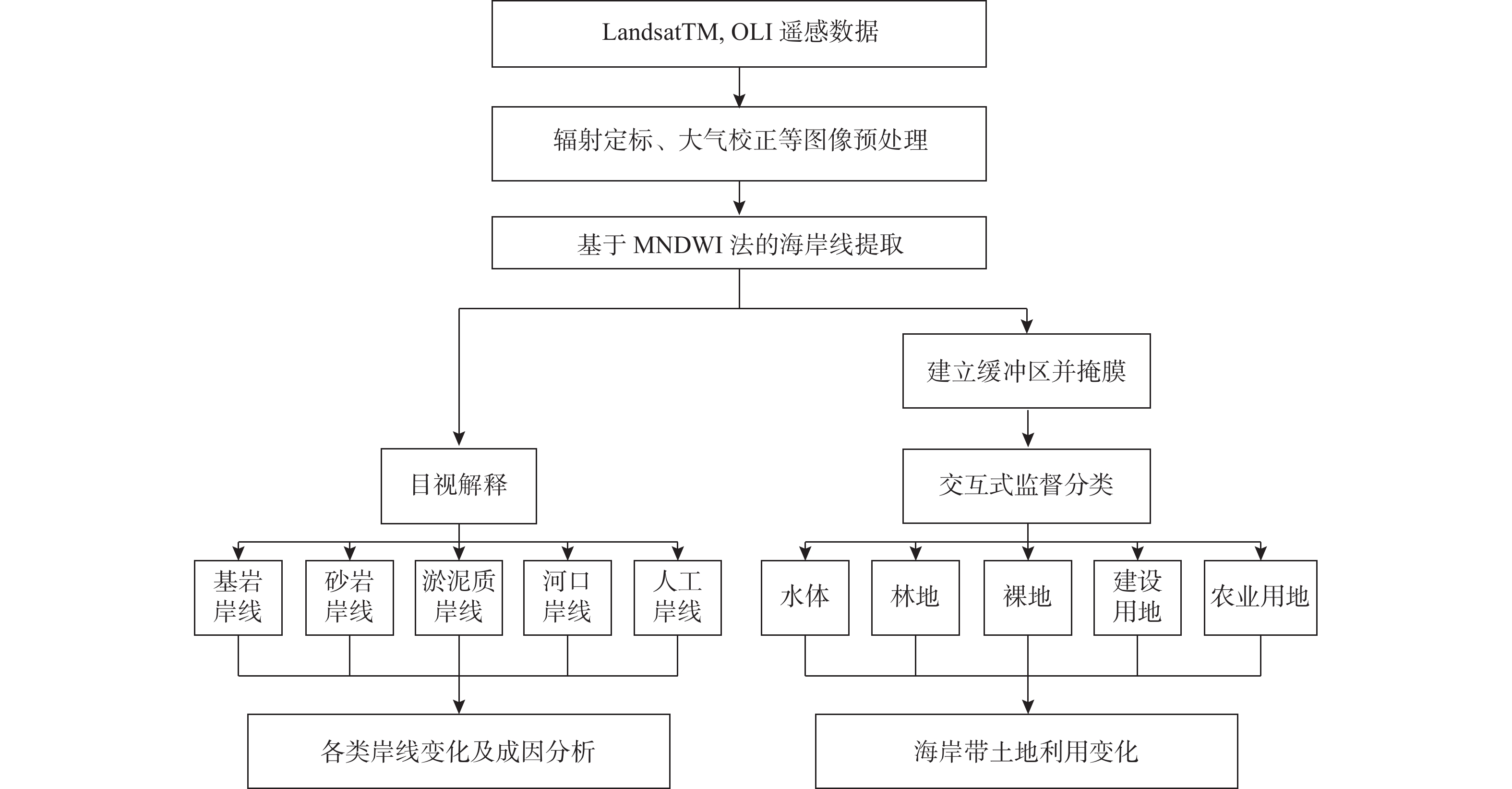
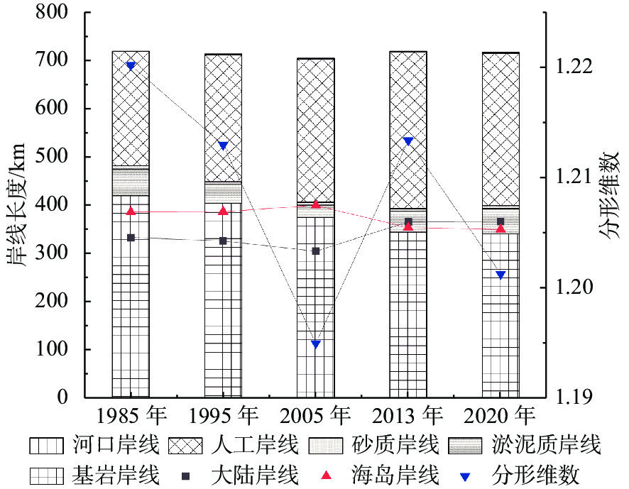
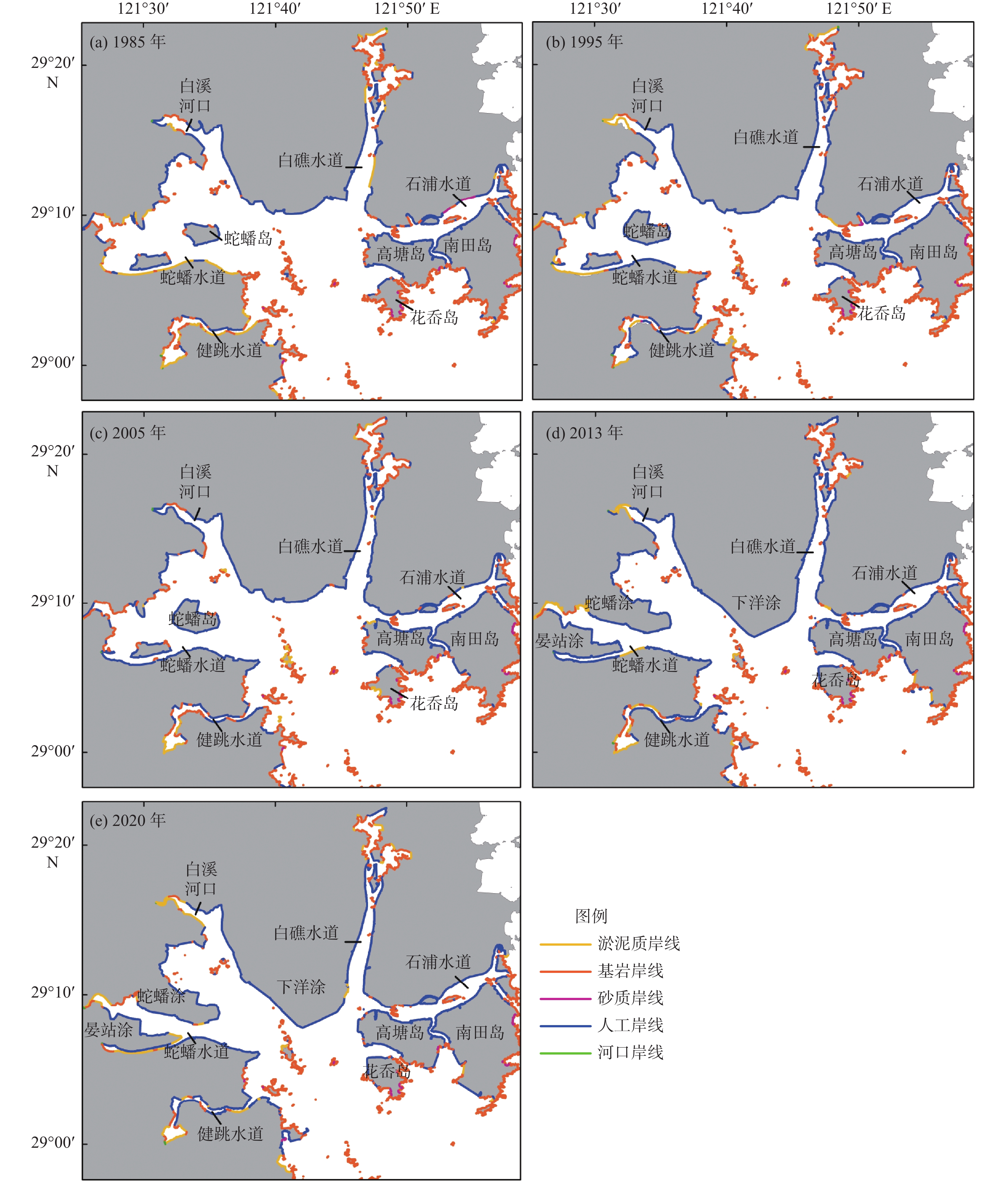
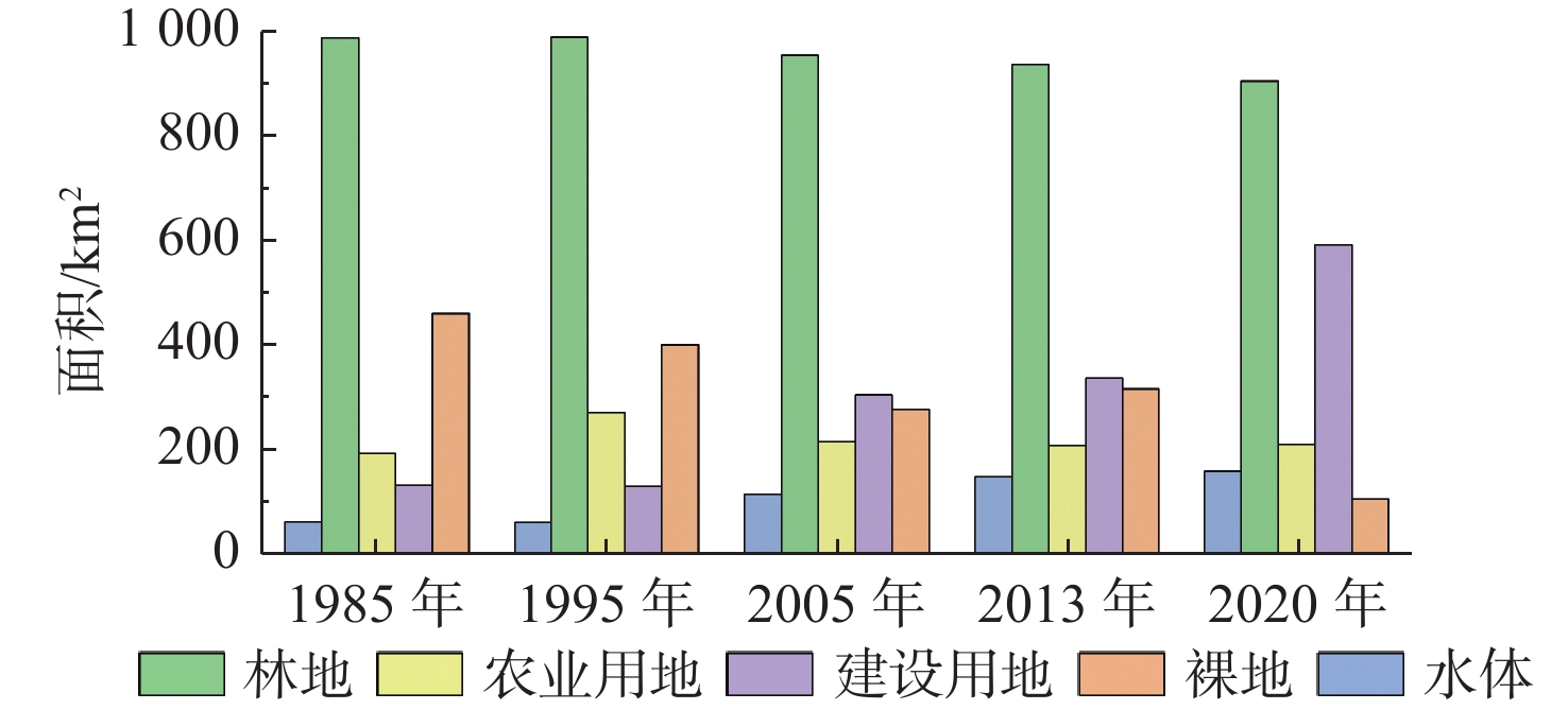
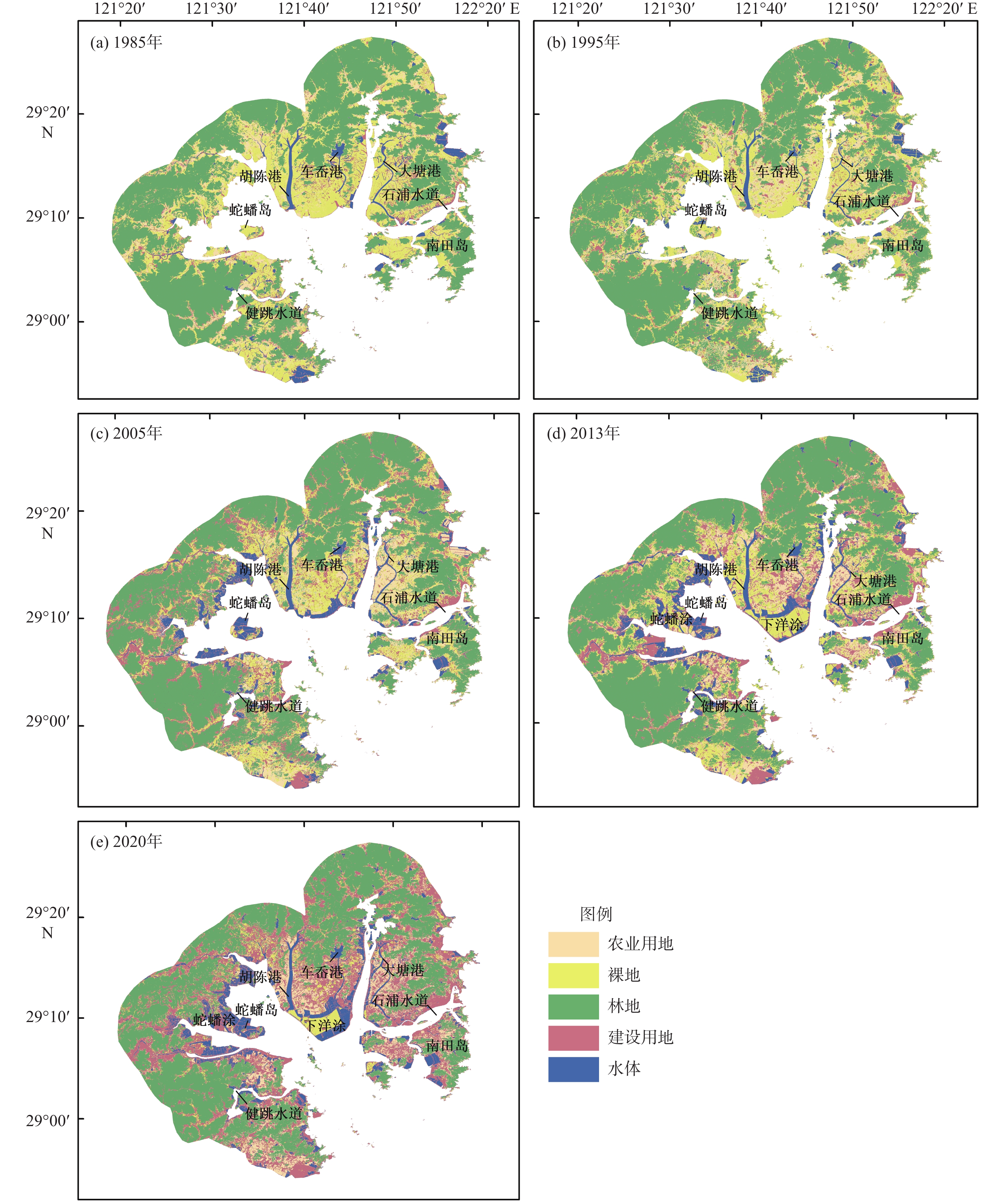
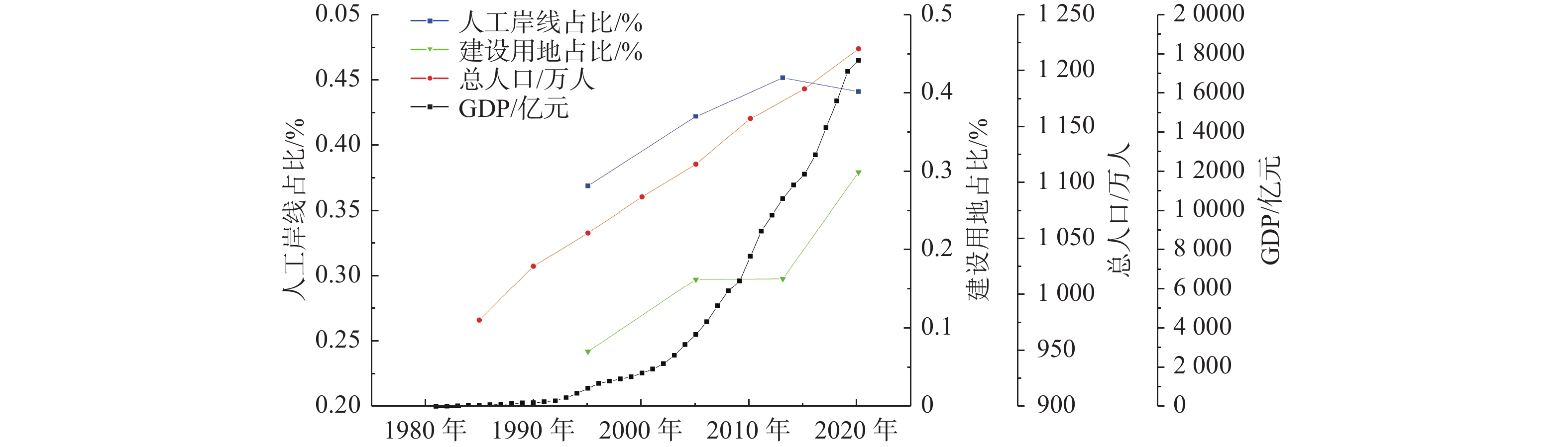
根据1985、1995、2005、2013和2020年的Landsat卫星图像,采用人机交互手段将三门湾海岸线分为基岩岸线、砂质岸线、淤泥质岸线、人工岸线和河口岸线。采用交互式监督分类将三门湾海岸带的土地利用分为水体、林地、裸地、建设用地和农业用地。研究结果表明:近40年三门湾人工岸线和基岩岸线变化最大,分别增加了80.3 km和减少了79.3 km;近40年三门湾海岸带面积累计增加了130 km2,建设用地和水体是围填海新增土地的主要利用类型,主要的土地转移形式为裸地向建设用地、农业用地的转变以及林地转为建设用地;近40年三门湾岸线分形维数由1.22减小至1.201,人工岸线比例和建设用地占比分别上升了13%和22.57%,总体上呈现向海推进、人工化加强的趋势。人类活动是造成三门湾岸线及海岸带变化的主要原因,随着对海岸带保护与合理利用的推进,三门湾海岸带开发利用格局正逐渐稳中向好。
-
关键词:
- Landsat卫星图像 /
- 三门湾 /
- 岸线时空变化 /
- 土地利用 /
- 遥感
Abstract:The coastline of Sanmen Bay in Zhejiang Province, East China was classified as rocky coastline, sandy coastline, muddy coastline, artificial coastline, and estuary coastline by human-computer interaction based on the Landsat satellite images of 1985, 1995, 2005, 2013, and 2020. The landuse types in the coastal zone of Sanmen Bay were classified as water bodies, forest, bare land, urban, and agriculture using interactive supervision. The results represent that rocky coastline and artificial coastline in the bay have been changed significantly in the past 40 years. Most prominently, the artificial coastline was increased by 80.3 km while the rocky coastline decreased by 79.3 km. The urban and water bodies were the major landuse of recently reclaimed area, which has extended the coastal zone of Sanmen Bay by 130 km2 in accumulation in the last 40 years. The conversions from bare land to urban, bare land to agricultural, and forest to urban are the primary land transfer types in the Sanmen Bay coastal zone. In the past 40 years, the fractal dimension of Sanmen Bay coastline has been decreased from 1.22 to 1.201, and the proportion of artificial coastline and urban has been increased by 13% and 22.57% respectively, in general trends of seaward advancement and rising artificiality/urbanization. Human activities are primarily responsible for the changes in the coastline and coastal zone land use of Sanmen Bay. With the implementation of protection and rational use of the coastal zone, the development and exploitation of the Sanmen Bay coastal zone has been gradually improving and stabilizing.
-

-
表 1 遥感影像数据信息
Table 1. Information of the remote sensing image data
过境时间
(年-月-日T时:分:秒)卫星类型 传感器 分辨率/m 轨道编号 云量/% 过境时刻石浦潮位站潮位/m 2020-12-22T02:25:51 Landsat-8 OLI 30 118-40 0.27 0.08 2020-08-16T02:25:33 Landsat-8 OLI 30 118-40 10.24 0.07 2020-10-04T02:25:42 Landsat-8 OLI 30 117-40 14.61 −1.38 2013-04-12T02:27:41 Landsat-8 OLI 30 118-40 0.35 −0.38 2013-08-29T02:27:35 Landsat-8 OLI 30 118-40 10.17 0.13 2013-12-03T02:27:09 Landsat-8 OLI 30 118-40 1.54 0.42 2005-11-27T02:14:16 Landsat-5 TM 30 118-40 0 0.13 2005-06-04T02:13:02 Landsat-5 TM 30 118-40 4.1 −0.08 1995-09-13T01:27:38 Landsat-5 TM 30 118-40 0 −1.93 1995-08-12T01:29:09 Landsat-5 TM 30 118-40 0.08 −2.79 1995-11-16T01:25:04 Landsat-5 TM 30 118-40 2.83 0.01 1985-11-09T01:18:52 Landsat-5 TM 30 117-40 0 0.06  下载: 导出CSV
表 2 海岸线解译标志
Table 2. Interpretation marks of the coastline
岸线类型 波段组合(R、G、B) 解译标志 基岩岸线 NIR、Red、Green 具有明显的凹凸感和山脉纹理特征,分布散乱,近岸植被多呈浅红色或暗红色 淤泥质岸线 Red、NIR、Green 在红光波段下反射率较低,多呈现为棕灰色,可结合岸线后方植被、养殖池塘等识别 砂质岸线 NIR、Red、Green 岸线平直,向陆侧砂砾含水量低、光谱反射率高,为亮白色 河口岸线 NIR、SWIR1、Red 主要为河流入海口的河道断面及其延伸部分分辨率较低的自然岸线 人工岸线 SWIR2、SWIR1、Red 几何形状较为规则,主要为海堤、水工建筑物(防潮闸、水坝等)与港口码头等岸线形式
下载: 导出CSV
表 3 三门湾各特征时段岸线变化
Table 3. Variation of coastline change in the Sanmen Bay in different characteristic years
年份 基岩岸线 砂质岸线 淤泥质岸线 人工岸线 河口岸线 时段内变化 总变化 变化长
度/km年变化
率/%变化长
度/km年变化
率/%变化长
度/km年变化
率/%变化长
度/km年变化
率/%变化长度/km 年变化率/% 变化长度/km 年变化率/% 变化长度/km 年变化率/% 1985—1995 −16.5 −0.41 −1.7 −2.97 −15.4 −3.88 27.4 1.04 0.23 1.97 −6 −0.08 2.95 −0.01 1995—2005 −28.6 −0.76 −0.23 −0.41 −14.2 −5.56 34.3 1.15 0.02 0.13 −8.75 −0.12 2005—2013 −30.4 −1.1 −0.32 −0.77 17.6 5.10 27.6 1.06 0.35 2.88 14.8 0.26 2013—2020 −3.82 −0.16 0.64 1.57 9.03 2.48 −8.9 −0.4 0.03 0.28 −3.01 −0.06
下载: 导出CSV
表 4 三门湾1985和2020年土地利用转移矩阵
Table 4. Cross-tabulation of landuse classes area in the Sanmen Bay between 1985 and 2020
km2 特征年份 2020年 合计 1985年 土地利用类别 农业用地 裸地 林地 建设用地 水体 农业用地 —— 18.98 18.18 105.85 11.26 154.26 裸地 115.32 —— 24.56 228.35 49.64 417.87 林地 35.47 13.12 —— 83.12 4.44 136.14 建设用地 17.74 8.42 10.03 —— 12.54 48.74 水体 1.64 1.72 0.47 26.65 —— 30.48 围填海新增用地 1.48 23.22 0 59.40 49.82 133.92 合计 171.65 65.46 53.25 503.37 127.69
下载: 导出CSV
-
[1] 丁晟平,崔胜辉,徐礼来,等. 1957—2019年厦门市马銮湾海岸线和围填海时空演变及互动关系分析[J]. 应用海洋学学报,2021,40(2):260-270.
[2] 张翔,王霄鹏,黄安齐,等. 基于遥感影像提取山东半岛复杂海岸线及海岸线多年变迁研究[J]. 海洋湖沼通报,2021,43(2):171-181.
[3] ABDULLAH A M,MASRUR A,ADNAN M S G,et al. Spatio-temporal patterns of land use/land cover change in the heterogeneous coastal region of Bangladesh between 1990 and 2017[J]. Remote Sensing,2019,11(7):790. doi: 10.3390/rs11070790
[4] HUSSEIN K,ALKAABI K,GHEBREYESUS D,et al. Land use/land cover change along the eastern coast of the UAE and its impact on flooding risk[J]. Geomatics, Natural Hazards and Risk,2020,11(1):112-130. doi: 10.1080/19475705.2019.1707718
[5] KAYA I A,GORGUN E K. Land use and land cover change monitoring in Bandirma (Turkey) using remote sensing and geographic information systems[J]. Environmental Monitoring and Assessment,2020,192(7):430. doi: 10.1007/s10661-020-08411-1
[6] 范剑超,姜大伟,赵建华,等. GF-3号SAR卫星遥感围填海监测方法研究:以大连金州湾为例[J]. 海洋科学,2017,41(12):60-65.
[7] 张华玉,秦年秀,汪军能,等. 广西海岸带土地利用时空格局及其驱动因子[J]. 水土保持研究,2022,29(3):367-374.
[8] 刘永超,李加林,王新新,等. 浙江三门湾湿地遥感时间序列演变分析[J]. 自然资源学报,2022,37(4):1036-1048.
[9] 刘晓凤,段晓勇,田元,等. 三门湾水体营养盐变化及其对人类活动的响应[J]. 海洋地质前沿,2021,37(5):46-56.
[10] LIU L,ZHANG X J,CHEN Z Q,et al. Assessment of ecological sustainability for international bays in the context of common prosperity:a case study of Sanmen Bay in Zhejiang Province[J]. Frontiers in Environmental Science,2022,10:863.
[11] CHEN X Y,ZHANG J,MA Y,et al. Monitoring and analysis of coastline changes of the Sanmen Bay with remote sensing during the past 40 years[J]. Marine Sciences,2015,39(2):43-49.
[12] 徐涵秋. 利用改进的归一化差异水体指数(MNDWI)提取水体信息的研究[J]. 遥感学报,2005,9(5):589-595.
[13] HU R R,YAO L J,YU J,et al. Remote sensing of the coastline variation of the Guangdong-Hongkong-Macao Greater Bay Area in the past four decades[J]. Journal of Marine Science and Engineering,2021,9(12):1318. doi: 10.3390/jmse9121318
[14] MANDELBROT B. How long is the coast of Britain? Statistical self-similarity and fractional dimension[J]. Science (New York,NY),1967,156(3775):636-638.
[15] 朱晓华,蔡运龙. 中国海岸线分维及其性质研究[J]. 海洋科学进展,2004,22(2):156-162.
[16] 林明祥,蔡廷禄,王欣凯,等. 近百年来浙江三门湾海岸线时空演变特征[J]. 海洋学研究,2021,39(1):47-55.
[17] WANG X,LIU Y L,LING F,et al. Spatio-temporal change detection of Ningbo coastline using landsat time-series images during 1976-2015[J]. ISPRS International Journal of Geo-Information,2017,6(3):68. doi: 10.3390/ijgi6030068
[18] 夏小明,谢钦春. 浙江三门湾海岸发育与持续利用[J]. 海洋通报,1996,15(4):49-57.
[19] YU Z N,WU C F,TAN Y Z,et al. The dilemma of land expansion and governance in rural China:a comparative study based on three townships in Zhejiang Province[J]. Land Use Policy,2018,71:602-611. doi: 10.1016/j.landusepol.2017.09.054
-


图(8)
表(4)
计量
- 文章访问数: 609
- PDF下载数: 81
- 施引文献: 0