

Three-dimensional reconstruction and structural surface identification of high steep slopes based on UAV close-range photogrammetry
-
摘要:
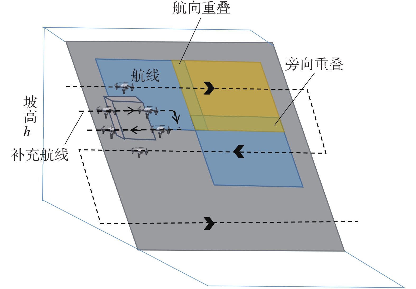
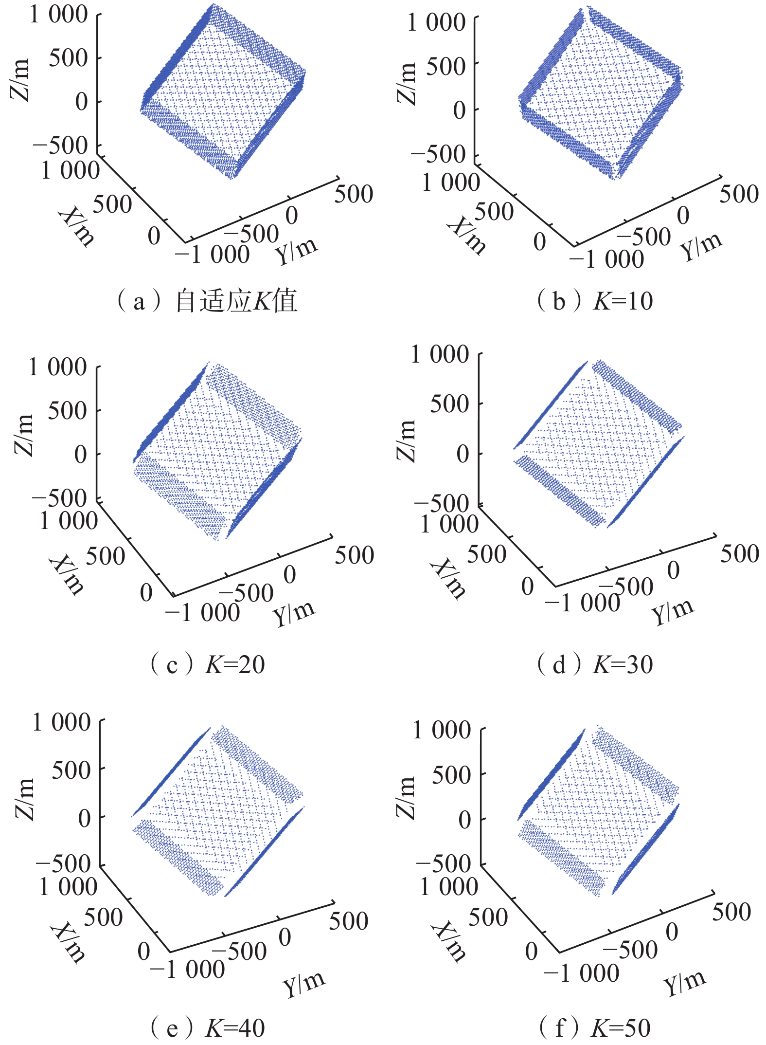
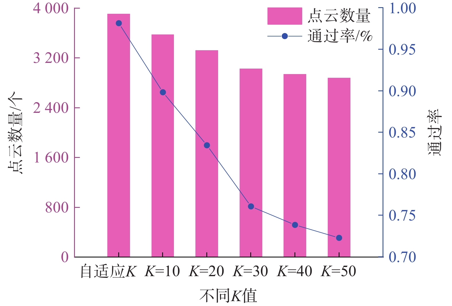
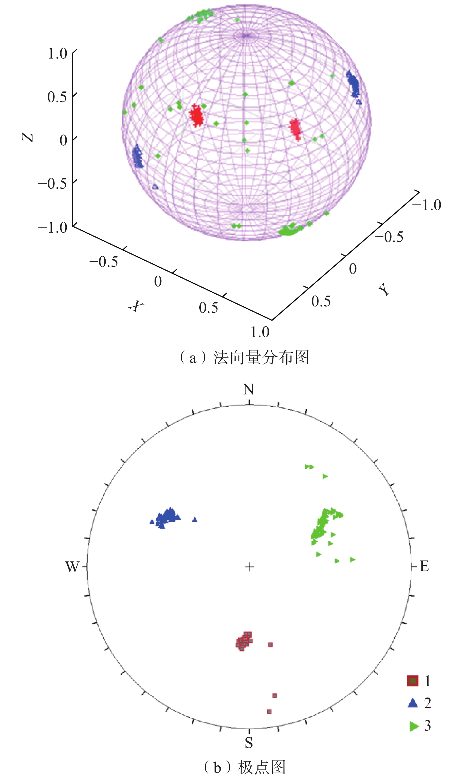
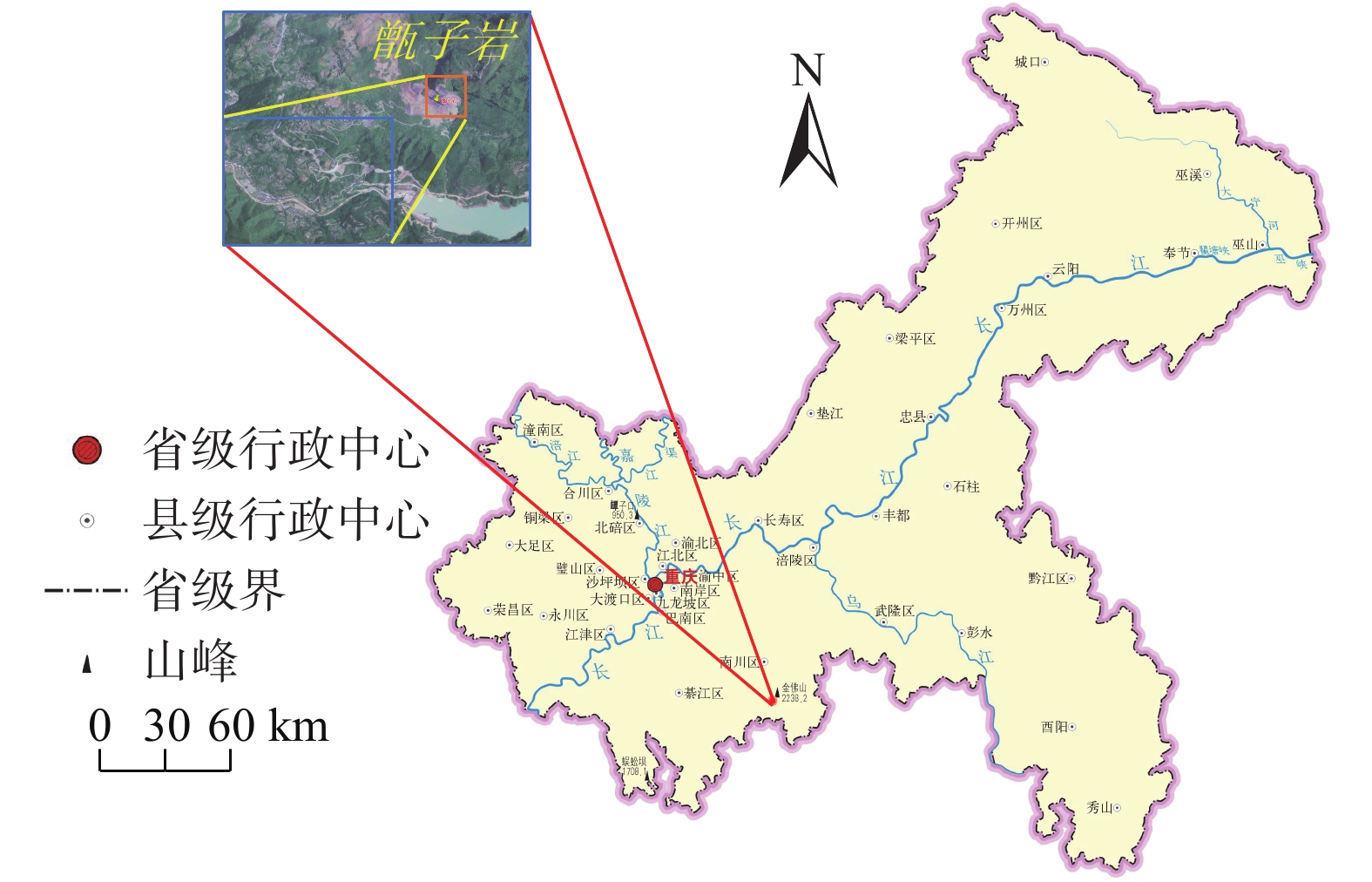
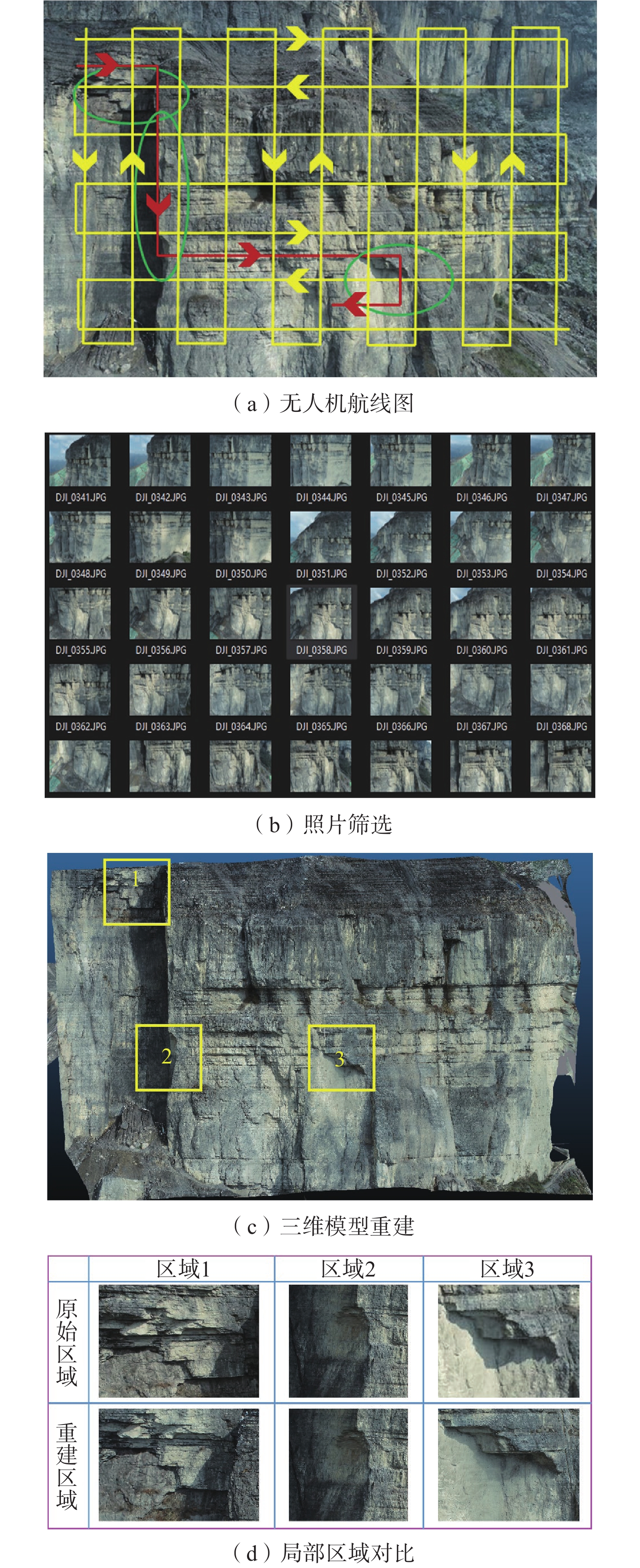
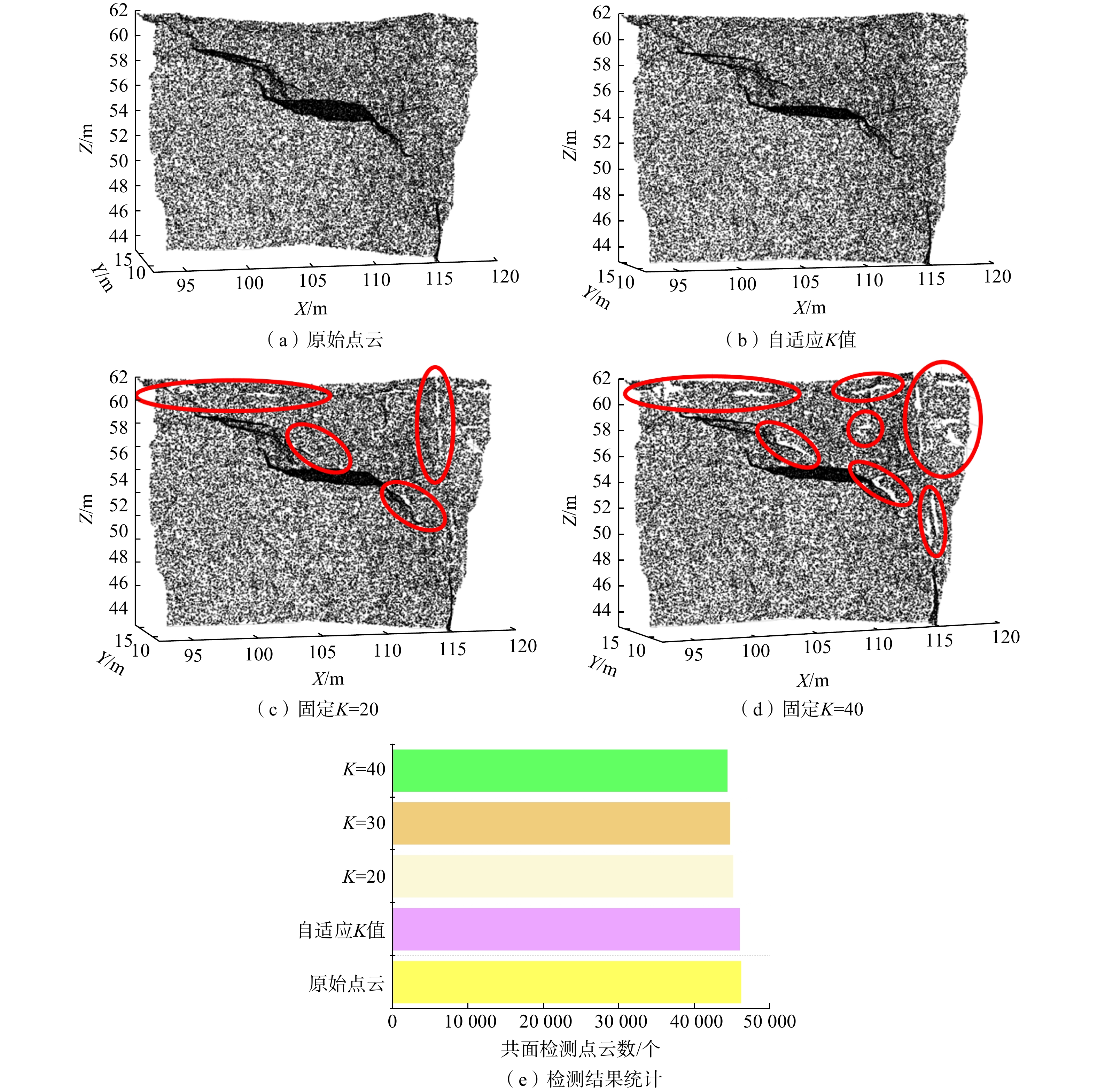
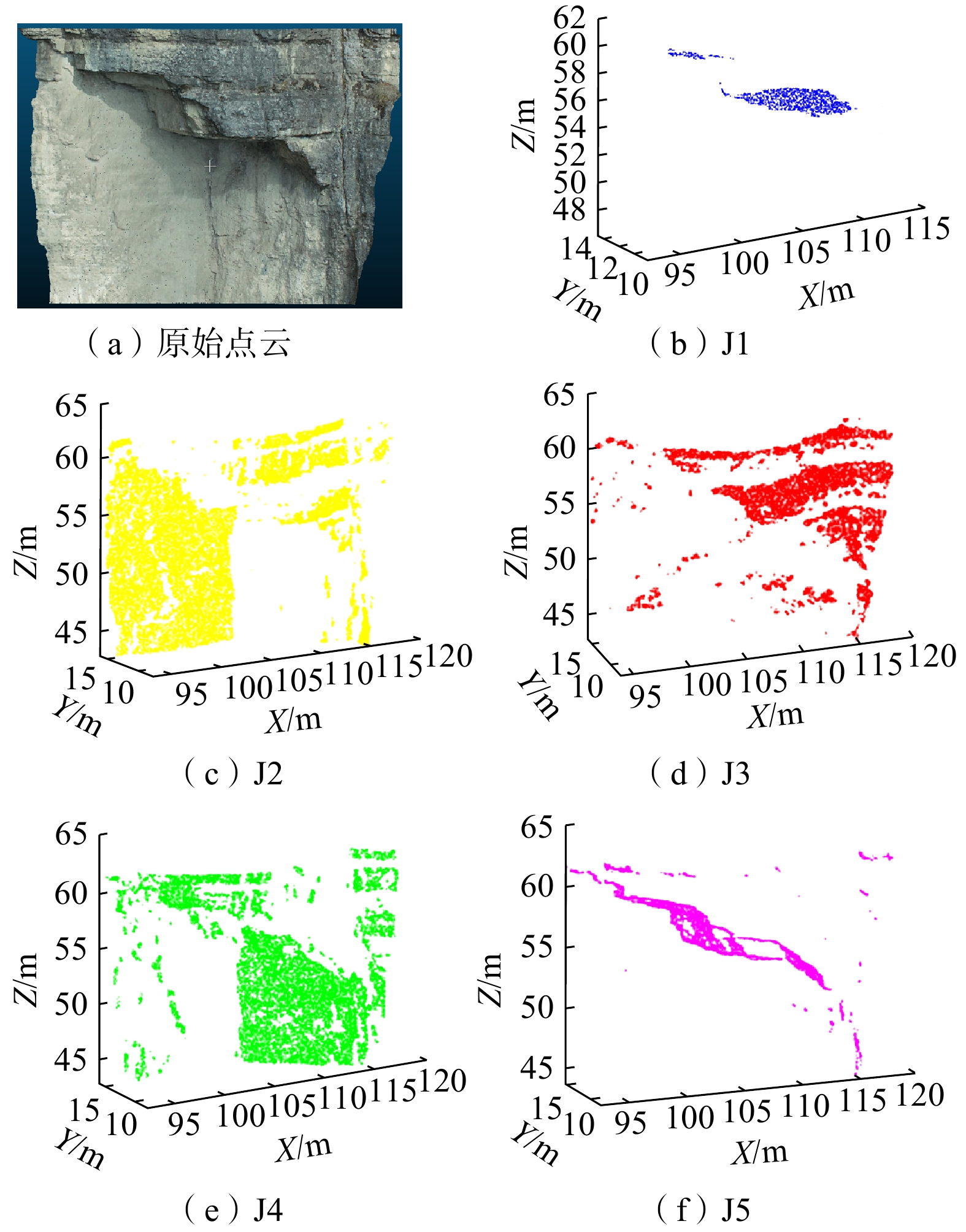
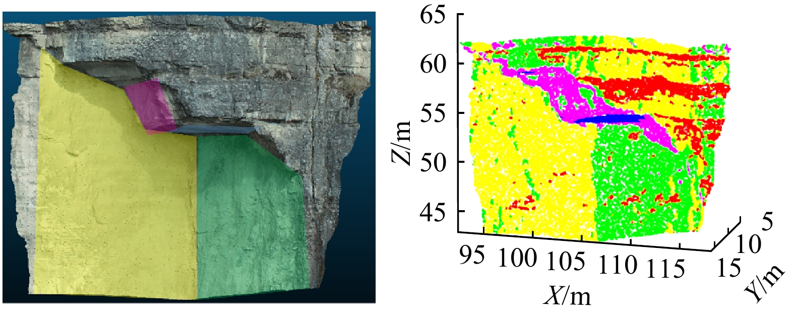
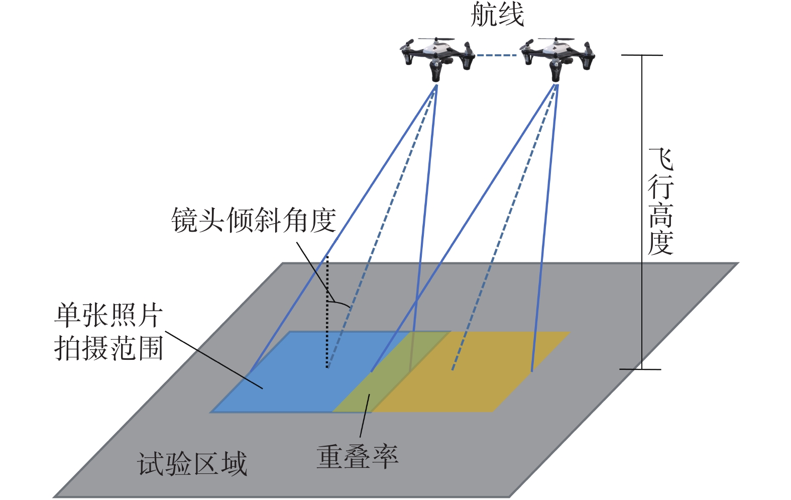
地质灾害调查可及时发现隐患、发出预警,避免生命财产损失。为解决高陡边坡调查风险高、效率低等问题,提出了基于无人机贴近摄影的高陡边坡三维重建与结构面识别方法。以重庆南川甑子岩为例,首先通过无人机贴近摄影和航线补充摄影获取高清航拍图,利用SFM-MVS算法构建精细三维模型和三维点云;然后提出自适应KNN算法,提高点云共面性检测通过率,通过最小二乘法拟合最佳平面方程,利用遗传退火模糊C算法实现点云聚类;最后根据点云协方差矩阵特征值和特征向量反算点云平面参数和法向量,并完成结构面识别和结构面产状参数提取。结果表明点云共面性检测通过率达99.6%,识别产状最大差值仅为4.82°。研究成果可为高陡边坡地质信息快速获取、稳定性评价及防灾减灾提供思路。
Abstract:Geological disaster investigations enable timely detection of hazards, issuance of early warnings, and prevention of loss of life and property. To address the challenges of high risk and low efficiency of high steep slopes investigation, this study proposes a method of three-dimensional reconstruction and structural plane identification of high steep slope based on UAV close-range photogrammetry. Using Zengziyan in Nanchuan, Chongqing as a case study, the process begins with acquiring high-definition aerial photographs through UAV close-range and supplemental route photogrammetry. The SFM-MVS algorithm is utilized to construct detailed 3D models and point clouds. An adaptive KNN algorithm is introduced to enhance the coplanarity detection passing rate in point clouds, while optimal planar equations are fitted using the least squares method. Point cloud clustering is achieved using a genetic annealing fuzzy C algorithm. Finally, according to the point cloud covariance matrix eigenvalues and eigenvectors, the point cloud plane parameters and normal vectors are inverted, and the structural surface identification and structural surface yield parameters extraction are completed. The results indicate a 99.6% passing rate for point cloud coplanarity detection, with a maximum deviation in identified orientation parameters of only 4.82°. This research provide insights for rapid acquisition of geological information, stability evaluation, and disaster prevention and mitigation for high steep slopes.
-

-
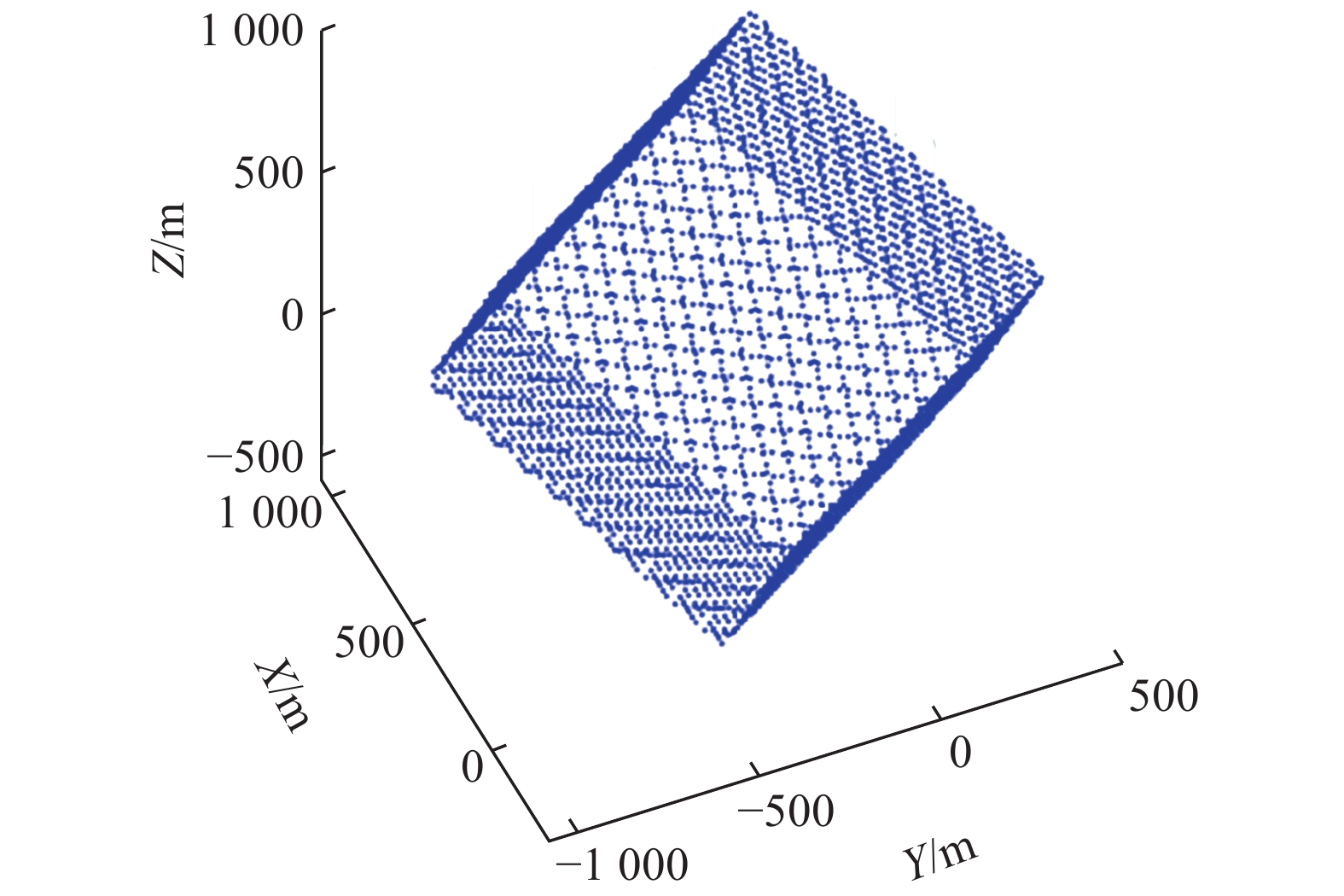
表 1 六面体点云表面产状
Table 1. Hexahedral point cloud surface orientations
序号 倾向/(°) 倾角/(°) 点数/个 1 0 45 1 326 2 125 60 1 326 3 235 60 1 326  下载: 导出CSV
表 2 点云数据平面参数a、b、c、d的计算结果(部分)
Table 2. Calculation results for point cloud plane parameters a, b, c, d (partial)
序号 a b c d 1 0.051252697 − 0.54764324 0.83514071 664.38898 2 0.051252544 − 0.54764354 0.83514059 664.85925 ┇ ┇ ┇ ┇ ┇ 1879 0.50000018 0.70710671 − 0.50000000 500.00012 1880 0.50000006 0.70710665 − 0.50000000 500.00006 ┇ ┇ ┇ ┇ ┇ 2525 0.70710677 −1.0955361e-9 0.70710683 500 2526 0.70710671 1.5848286e-8 0.70710689 499.99994 ┇ ┇ ┇ ┇ ┇
下载: 导出CSV
表 3 六面体点云表面产状与聚类结果产状对比
Table 3. Comparison of hexahedral point cloud surface occurrence with clustering result occurrence
序号 聚类中心 倾向/(°) 差值/(°) 倾角/(°) 差值/(°) 1 已知 0 0.09 45 0.19 聚类结果 0.09 45.19 2 已知 125 0.08 60 0.30 聚类结果 124.92 60.30 3 已知 235 0.2 60 0.69 聚类结果 234.80 60.69
下载: 导出CSV
表 4 结构面产状信息
Table 4. Discontinuity plane orientations information
结构面 识别倾向/(°) 转换后倾向/(°) 倾角/(°) J1 273.55 176.45 5.10 J2 119.82 330.18 88.36 J3 261.47 188.53 67.67 J4 239.14 210.86 89.05 J5 27.43 62.57 50.30
下载: 导出CSV
表 5 结构面产状识别
Table 5. Discontinuity plane orientation identification
分组 识别结构面 倾向/(°) 倾向差值/(°) 倾角/(°) 倾角差值/(°) 陡倾结构面1 实测产状 210 0.86 89 0.05 识别产状 210.86 89.05 陡倾结构面2 实测产状 325 4.82 89 0.64 识别产状 330.18 88.36
下载: 导出CSV
-
[1] NESBIT P R,HUBBARD S M,HUGENHOLTZ C H. Direct georeferencing UAV-SfM in high-relief topography:Accuracy assessment and alternative ground control strategies along steep inaccessible rock slopes[J]. Remote Sensing,2022,14(3):490. doi: 10.3390/rs14030490
[2] 宣程强,章杨松,许文涛. 基于数字表面模型的岩体结构面产状获取[J]. 水文地质工程地质,2022,49(1):75 − 83. [XUAN Chengqiang,ZHANG Yangsong,XU Wentao. Extraction of the discontinuity orientation from a digital surface model[J]. Hydrogeology & Engineering Geology,2022,49(1):75 − 83. (in Chinese with English abstract)]
XUAN Chengqiang, ZHANG Yangsong, XU Wentao. Extraction of the discontinuity orientation from a digital surface model[J]. Hydrogeology & Engineering Geology, 2022, 49(1): 75 − 83. (in Chinese with English abstract)
[3] 于海明,张熠斌,方向辉,等. 综合InSAR技术和多源SAR数据在滑坡变形监测中的应用——以吉林治新村滑坡为例[J]. 中国地质灾害与防治学报,2024,35(1):155 − 162. [YU Haiming, ZHANG Yibin, FANG Xianghui, et al. Application of multiple InSAR techniques and SAR data from multisources to landslide deformation monitoring:A case study of the Zhixincun landslide in Jilin Province[J]. The Chinese Journal of Geological Hazard and Control,2024,35(1):155 − 162. (in Chinese with English abstract)]
YU Haiming, ZHANG Yibin, FANG Xianghui, et al. Application of multiple InSAR techniques and SAR data from multisources to landslide deformation monitoring: A case study of the Zhixincun landslide in Jilin Province[J]. The Chinese Journal of Geological Hazard and Control, 2024, 35(1): 155 − 162. (in Chinese with English abstract)
[4] 王猛,何德伟,贾志宏,等. 基于多源遥感数据的高位滑坡特征分析——以广元市利州区荣山镇岩窝村滑坡为例[J]. 中国地质灾害与防治学报,2023,34(6):57 − 68. [WANG Meng, HE Dewei, JIA Zhihong, et al. Analysis of high-position landslide characteristics based on multi-source remote sensing data: A case study of the Yanwo Village landslide in Rongshan Town, Lizhou District, Guangyuan City[J]. The Chinese Journal of Geological Hazard and Control,2023,34(6):57 − 68. (in Chinese with English abstract)]
WANG Meng, HE Dewei, JIA Zhihong, et al. Analysis of high-position landslide characteristics based on multi-source remote sensing data: A case study of the Yanwo Village landslide in Rongshan Town, Lizhou District, Guangyuan City[J]. The Chinese Journal of Geological Hazard and Control, 2023, 34(6): 57 − 68. (in Chinese with English abstract)
[5] 张本浩,魏云杰,杨成生,等. 西藏然乌地区地质灾害隐患点InSAR识别与监测[J]. 中国地质灾害与防治学报,2022,33(1):18 − 26. [ZHANG Benhao,WEI Yunjie,YANG Chengsheng,et al. InSAR identification and monitoring of geological hazards in Ranwu region of Xizang[J]. The Chinese Journal of Geological Hazard and Control,2022,33(1):18 − 26. (in Chinese with English abstract)]
ZHANG Benhao, WEI Yunjie, YANG Chengsheng, et al. InSAR identification and monitoring of geological hazards in Ranwu region of Xizang[J]. The Chinese Journal of Geological Hazard and Control, 2022, 33(1): 18 − 26. (in Chinese with English abstract)
[6] 卫童瑶,殷跃平,李滨,等. 西藏笨多高位变形体遥感解译与危险性预测分析[J]. 中国地质灾害与防治学报,2021,32(3):17 − 24. [WEI Tongyao,YIN Yueping,LI Bin,et al. Remote sensing interpretation and risk prediction analysis of Benduo high deformation body in Xizang[J]. The Chinese Journal of Geological Hazard and Control,2021,32(3):17 − 24. (in Chinese with English abstract)]
WEI Tongyao, YIN Yueping, LI Bin, et al. Remote sensing interpretation and risk prediction analysis of Benduo high deformation body in Xizang[J]. The Chinese Journal of Geological Hazard and Control, 2021, 32(3): 17 − 24. (in Chinese with English abstract)
[7] 陈仁朋,吴熠文,余加勇,等. 基于无人机影像序列的城市精细化三维模型精度评估[J]. 湖南大学学报(自然科学版),2019,46(11):172 − 180. [CHEN Renpeng,WU Yiwen,YU Jiayong,et al. Method accuracy evaluations of building urban detailed 3D model based on the unmanned aerial vehicle image sequences and its accuracy evaluatios[J]. Journal of Hunan University (Natural Sciences),2019,46(11):172 − 180. (in Chinese with English abstract)]
CHEN Renpeng, WU Yiwen, YU Jiayong, et al. Method accuracy evaluations of building urban detailed 3D model based on the unmanned aerial vehicle image sequences and its accuracy evaluatios[J]. Journal of Hunan University (Natural Sciences), 2019, 46(11): 172 − 180. (in Chinese with English abstract)
[8] 余加勇,薛现凯,陈昌富,等. 基于无人机倾斜摄影的公路边坡三维重建与灾害识别方法[J]. 中国公路学报,2022,35(4):77 − 86. [YU Jiayong,XUE Xiankai,CHEN Changfu,et al. Three-dimensional reconstruction and disaster identification of highway slope using unmanned aerial vehicle-based oblique photography technique[J]. China Journal of Highway and Transport,2022,35(4):77 − 86. (in Chinese with English abstract)] doi: 10.3969/j.issn.1001-7372.2022.04.005
YU Jiayong, XUE Xiankai, CHEN Changfu, et al. Three-dimensional reconstruction and disaster identification of highway slope using unmanned aerial vehicle-based oblique photography technique[J]. China Journal of Highway and Transport, 2022, 35(4): 77 − 86. (in Chinese with English abstract) doi: 10.3969/j.issn.1001-7372.2022.04.005
[9] YAN Jianhua,CHEN Jianping,ZHANG Yansong,et al. Semi-automatic extraction of dangerous rock blocks from jointed rock exposures based on a discontinuity trace map[J]. Computers and Geotechnics,2023,156:105265. doi: 10.1016/j.compgeo.2023.105265
[10] CUI Shenghua,LIANG Yufei,PEI Xiangjun,et al. Structural characteristics of landslide failure boundaries using three-dimensional point clouds:A case study of the Zhaobiyan landslide,China[J]. Bulletin of Engineering Geology and the Environment,2023,82(4):127. doi: 10.1007/s10064-023-03140-4
[11] 熊开治,任志远,赵亚龙,等. 基于无人机航测的丹霞地貌区危岩结构面识别与三维裂隙网络模型——以重庆四面山景区为例[J]. 中国地质灾害与防治学报,2021,32(5):62 − 69. [XIONG Kaizhi,REN Zhiyuan,ZHAO Yalong,et al. Identification of dangerous rock structural planes and fracture network model in Danxia landform based on UAV aerial survey:A case study at simianshan scenic area of Chongqing[J]. The Chinese Journal of Geological Hazard and Control,2021,32(5):62 − 69. (in Chinese with English abstract)]
XIONG Kaizhi, REN Zhiyuan, ZHAO Yalong, et al. Identification of dangerous rock structural planes and fracture network model in Danxia landform based on UAV aerial survey: A case study at simianshan scenic area of Chongqing[J]. The Chinese Journal of Geological Hazard and Control, 2021, 32(5): 62 − 69. (in Chinese with English abstract)
[12] 周成凯,李远耀,王宁涛,等. 基于小型无人机的高位危岩快速调查与稳定性评价[J]. 科学技术与工程,2021,21(10):3920 − 3928. [ZHOU Chengkai,LI Yuanyao,WANG Ningtao,et al. Application of micro unmanned aerial vehicle in a quick investigation and stability assessment of high dangerous rock mass[J]. Science Technology and Engineering,2021,21(10):3920 − 3928. (in Chinese with English abstract)] doi: 10.3969/j.issn.1671-1815.2021.10.008
ZHOU Chengkai, LI Yuanyao, WANG Ningtao, et al. Application of micro unmanned aerial vehicle in a quick investigation and stability assessment of high dangerous rock mass[J]. Science Technology and Engineering, 2021, 21(10): 3920 − 3928. (in Chinese with English abstract) doi: 10.3969/j.issn.1671-1815.2021.10.008
[13] 康尘云. 基于倾斜摄影的高位危岩特征获取和稳定性评价——以重庆万州观音山危岩带为例[J]. 中国地质灾害与防治学报,2022,33(5):66 − 75. [KANG Chenyun. Feature acquisition and stability evaluation of high dangerous rock mass based on oblique photography:A case study at Guanyinshan in Wanzhou,Chongqing Province[J]. The Chinese Journal of Geological Hazard and Control,2022,33(5):66 − 75. (in Chinese with English abstract)]
KANG Chenyun. Feature acquisition and stability evaluation of high dangerous rock mass based on oblique photography: A case study at Guanyinshan in Wanzhou, Chongqing Province[J]. The Chinese Journal of Geological Hazard and Control, 2022, 33(5): 66 − 75. (in Chinese with English abstract)
[14] KONG Deheng,SAROGLOU C,WU Faquan,et al. Development and application of UAV-SfM photogrammetry for quantitative characterization of rock mass discontinuities[J]. International Journal of Rock Mechanics and Mining Sciences,2021,141:104729. doi: 10.1016/j.ijrmms.2021.104729
[15] ADHIKARY S,BANERJEE S. Introduction to distributed nearest hash:On further optimizing cloud based distributed kNN variant[J]. Procedia Computer Science,2023,218:1571 − 1580. doi: 10.1016/j.procs.2023.01.135
[16] 陈昌富,何旷宇,余加勇,等. 基于无人机贴近摄影的高陡边坡结构面识别[J]. 湖南大学学报(自然科学版),2022,49(1):145 − 154. [CHEN Changfu,HE Kuangyu,YU Jiayong,et al. Identification of discontinuities of high steep slope based on UAV nap-of-the-object photography[J]. Journal of Hunan University (Natural Sciences),2022,49(1):145 − 154. (in Chinese with English abstract)]
CHEN Changfu, HE Kuangyu, YU Jiayong, et al. Identification of discontinuities of high steep slope based on UAV nap-of-the-object photography[J]. Journal of Hunan University (Natural Sciences), 2022, 49(1): 145 − 154. (in Chinese with English abstract)
[17] 周福川,唐红梅,王林峰. 缓倾角塔柱状危岩压裂损伤-突变失稳预测[J]. 岩土力学,2022,43(5):1341 − 1352. [ZHOU Fuchuan,TANG Hongmei,WANG Linfeng. Catastrophe prediction of compression-induced fracturing and failure for a tower-shaped unstable rock mass with gentle dip angle[J]. Rock and Soil Mechanics,2022,43(5):1341 − 1352. (in Chinese with English abstract)]
ZHOU Fuchuan, TANG Hongmei, WANG Linfeng. Catastrophe prediction of compression-induced fracturing and failure for a tower-shaped unstable rock mass with gentle dip angle[J]. Rock and Soil Mechanics, 2022, 43(5): 1341 − 1352. (in Chinese with English abstract)
-

图(12)
表(5)
计量
- 文章访问数: 342
- PDF下载数: 48
- 施引文献: 0