

COMPILATION OF THE 1: 1 500 000 TECTONIC FACIES MAP OF NORTHEAST CHINA
-
摘要:
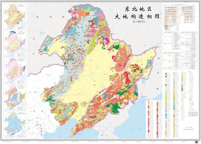
东北地区1:150万大地构造相图是2018年出版的一份区域性大地构造图.该图依据不断积累和丰富的基础地质资料,将大地构造理论研究与综合应用汇总和集成,是东北地区科技创新成果和技术方法进步转化应用的重要体现.此次编图以板块构造理论和大陆动力学思维为指导,以多岛洋、弧-盆系发展演化观点为切入点,运用大地构造相分析方法,研究东北地区地壳形成、演化历史,以及大地构造环境及其与成矿作用的时空关系.较系统地阐述了东北地区的岩石构造组合、建造构造与构造演化阶段的宏观背景.
Abstract:The 1:1 500 000 Tectonic Facies Map of Northeast China is a regional geotectonic map published in 2018. Based on accumulated abundant basic geological data, the map summarizes and integrates geotectonic theory study and comprehensive application, which is an important embodiment of scientific innovation achievements and technical progresses transformed to application in Northeast China. Guided by the theories of plate tectonics and continental dynamics, starting from the development and evolution of archipelagic ocean and arc-basin system, the map compilation applies the tectonic facies analysis method to study the crustal formation, evolution history, and geotectonic environment as well as its spatial-temporal relation with mineralization in Northeast China. It systematically expounds the macro-background of rock tectonic associations, formation structures and tectonic evolution stages in Northeast China.
-
Key words:
- Northeast China /
- plate tectonics /
- geotectonic facies /
- tectonic unit
-

-
表 1 东北地区构造单元划分简表
Table 1. Division of tectonic units in Northeast China
一级(相系) 二级(大相) 三级(相) 兴蒙造山系(Ⅰ) 额尔古纳地块(Ⅰ-1) 漠河前陆盆地(Ⅰ-1-1) 莫尔道嘎岩浆弧(Ⅰ-1-2) 大兴安岭弧盆系(Ⅰ-2) 海拉尔-呼玛弧后盆地(Ⅰ-2-1) 扎兰屯-多宝山岛弧(Ⅰ-2-2) 新林蛇绿混杂岩带(Ⅰ-2-3) 海拉尔裂谷盆地(Ⅰ-2-4) 锡林浩特-塔溪岩浆弧(Ⅰ-2-5) 贺根山蛇绿混杂岩带(Ⅰ-2-6) 小兴安岭-张广才岭弧盆系(Ⅰ-3) 伊春-延寿岩浆弧(Ⅰ-3-1) 张广才岭岩浆弧(Ⅰ-3-2) 松嫩盆地(Ⅰ-4) 松嫩裂谷盆地(Ⅰ-4-1) 太平沟-依兰-黄松俯冲增生杂岩(Ⅰ-5) 太平沟俯冲增生杂岩(Ⅰ-5-1) 依兰-穆棱俯冲增生杂岩(Ⅰ-5-2) 黄松俯冲增生杂岩(Ⅰ-5-3) 佳木斯-兴凯地块(Ⅰ-6) 三江盆地(Ⅰ-6-1) 麻山基底杂岩、兴东盖层陆表海盆地(Ⅰ-6-2) 兴凯陆表海盆地(Ⅰ-6-3) 虎头基底杂岩(Ⅰ-6-4) 完达山结合带(Ⅰ-7) 饶河增生混杂岩(Ⅰ-7-1) 完达山蛇绿混杂岩(Ⅰ-7-2) 索伦山-西拉木伦拼合带(Ⅱ) 西拉木伦拼合带(Ⅱ-1) 白音宝力道俯冲增生杂岩带(Ⅱ-1-1) 林西残余海盆地(Ⅱ-1-2) 柯单山蛇绿混杂岩带(Ⅱ-1-3) 吉林-汪清-珲春推测对接带(Ⅱ-1-4) 温都尔庙弧盆系(Ⅱ-2) 温都尔庙岩浆弧(Ⅱ-2-1) 通辽岩浆弧(Ⅱ-2-2) 磐石-百里坪岩浆弧(Ⅱ-2-3) 下二台-呼兰岩浆弧(Ⅱ-2-4) 华北古陆块(Ⅲ) 冀北陆块(Ⅲ-1) 赤峰岩浆弧(Ⅲ-1-1) 冀辽陆块(Ⅲ-2) 建平-旧庙古岩浆弧(Ⅲ-2-1) 汎河裂谷(Ⅲ-2-2) 燕辽裂谷(Ⅲ-2-3) 绥中-北镇古弧盆(Ⅲ-2-4) 下辽河裂谷盆地(Ⅲ-2-5) 渤海东陆块(Ⅲ-3) 龙岗古岩浆弧(Ⅲ-3-1) 太子河-浑江陆表海盆地(Ⅲ-3-2) 辽吉陆缘裂谷盆地(Ⅲ-3-3) 大连陆表海盆地(Ⅲ-3-4)  下载: 导出CSV
-
[1] 叶天竺, 黄崇轲, 邓志奇, 等.中华人民共和国地质图(1:2500000)[M].北京:中国地图出版社, 2004:前言Ⅰ-Ⅱ.
[2] 潘桂棠, 王立全, 尹福光, 等.从多岛弧盆系研究实践看板块构造登陆的魅力[J].地质通报, 2004, 23(9/10):933-939. http://d.old.wanfangdata.com.cn/Periodical/zgqydz200409016
[3] 潘桂棠, 肖庆辉, 陆松年, 等.大地构造相的定义、划分、特征及其鉴别标志[J].地质通报, 2008, 27(10):1613-1637. doi: 10.3969/j.issn.1671-2552.2008.10.004
[4] 潘桂棠, 肖庆辉, 陆松年, 等.中国大构造单元划分[J].中国地质, 2009, 36(1):1-28. http://d.old.wanfangdata.com.cn/Periodical/zgdizhi200901001
-

图(2)
表(1)
计量
- 文章访问数: 874
- PDF下载数: 105
- 施引文献: 0