

APPLICATION OF IN-SITU MEASURED SPECTRA DATA BY ASD FieldSpec3 ON LITHOLOGIC CLASSIFICATION IN SHUIMO-DAHE AREA
-
摘要:
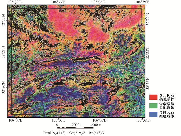
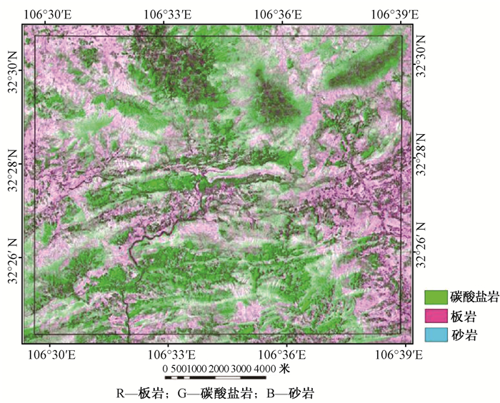
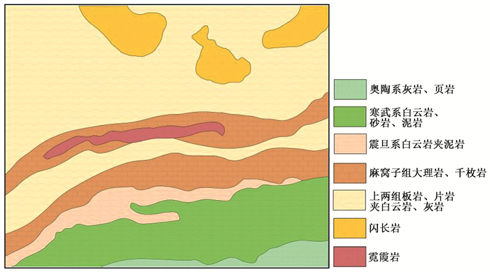
以四川省旺苍县水磨—大河地区为研究区, 利用美国ASD FieldSpec 3便携式地物光谱仪野外实测岩矿波谱数据和ASTER遥感影像数据, 基于GIS平台, 根据野外实测的岩石光谱曲线和USGS光谱库的典型岩石光谱曲线提取端元波谱, 对区域影像像元的光谱曲线进行匹配, 采用ENVI4.4软件自动信息提取与人机交互解译相结合的方式, 进行岩性分类, 可以有效地划分区内岩性界线, 满足填图需求, 对辅助该区区域基础地质调查、矿产普查等具有重要的应用价值。
Abstract:This paper chose the Shuimo-Dahe area of Sichuan Wangcang as its research area, use ASTER image and in-situ measured spectra data by ASD FieldSpec3 as the research object, extract mineral endmember information according to rock spectral curve from field survey data and USGS spectral library, match the spectral curve of image pixel, combine ENVI4.4 software for automatic information extraction and man-computer interactive interpretation, to conduct lithology classification, based on GIS, it has an important application value for basic geological survey and mineral survey.
-

-
[1] 童庆禧, 田国良.中国典型地物波谱及其特征分析[M].北京:科学出版社, 1990.
TONG Qing-xi, TIAN Guo-liang. Spectra and analysis of typical earth objects of China[M]. Beijing: Science Press, 1990.
[2] 王青华, 王润生, 郭小方.高光谱遥感技术在岩石识别中的应用[J].国土资源遥感, 2000, (4):39~43. doi: 10.6046/gtzyyg.2000.04.08
WANG Qing-hua, WANG Run-sheng, GUO Xiao-fang. Application for discrimination of rock using hyperspectrail remote sensing technique[J]. Remote Sensing for Land & Resources, 2000, (4): 39~43. doi: 10.6046/gtzyyg.2000.04.08
[3] 曹烨, 李胜荣, 申俊峰, 等.便携式短波红外光谱矿物测量仪(PIMA)在河南前河金矿热液蚀变研究中的应用[J].地质与勘探, 2008, (2):39~43. http://www.cnki.com.cn/Article/CJFDTOTAL-DZKT200802016.htm
CAO Ye, LI Sheng-rong, SHEN Jun-feng, et al. Application of Portable Infrared Mineral Analyzer (PIMA) in the Qianhe gold mine, Henan Province[J]. Geology and Prospecting, 2008, (2): 39~43. http://www.cnki.com.cn/Article/CJFDTOTAL-DZKT200802016.htm
[4] 孙卫东, 杨金中, 甘甫平, 等. 遥感矿物填图技术在阿吾拉勒山一带的应用研究[C]//第16届全国遥感技术学术交流会论文集. 北京: 地质出版社, 2007: 153-156.
SUN Wei-dong, YANG Jin-zhong, GAN Fu-ping, et al. The application and research of remote sensing mineral mapping on Awulale Mountain[C]//16th National Remote Sensing Technology Academic Exchange Conference Proceedings. Beijing: Geological Publishing House, 2007: 153~156.
[5] 四川省地质调查院. 四川南江地区矿产远景调查报告[R]. 成都: 四川省地质调查院, 2013.
Sichuan Geological Survey. Report of mineral proceeding research in Nanjiang area, Sichuan Province[R]. Chengdu: Sichuan Geological Survey, 2013.
[6] 叶成名. 基于高光谱遥感的青藏高原岩矿信息提取方法与应用研究[D]. 成都: 成都理工大学, 2011.
YE Cheng-ming. The research of rock mineral information extraction based on hyperspectral remote sensing in Tibetan Plateau[D]. Chengdu: Chengdu University of Technology, 2011.
[7] 时丕龙, 付碧宏, 二宫芳树.基于ASTER VNIRSWIR多光谱遥感数据识别与提取干旱地区岩性信息——以西南天山柯坪隆起东部为例[J].地质科学, 2010, 45(1):333~347. http://www.cnki.com.cn/Article/CJFDTOTAL-DZKX201001029.htm
SHI Pi-long, FU Bi-hong, Ninomiya Y. Detecting lithologic features from ASTER VNIR-SWIR multispectral data in the arid region: A case study in the eastern Kalpin uplift, southwest Tianshan[J]. Chinese Journal of Geology, 2010, 45(1): 333~347. http://www.cnki.com.cn/Article/CJFDTOTAL-DZKX201001029.htm
[8] 王志刚, 朱振海, 王红梅, 等.光谱角度填图方法及其在岩石识别中的应用[J].遥感学报, 1999, 3(1):60~65. doi: 10.11834/jrs.19990109
WANG Zhi-gang, ZHU Zhen-hai, WANG Hong-mei, et al. Applications of spectral angle mapping method in lithological identification[J]. Journal of Remote Sensing, 1999, 3(1): 60~65. doi: 10.11834/jrs.19990109
[9] 毕晓佳, 苗放, 叶成名, 等.Hyperion高光谱遥感岩性识别填图[J].物探化探计算技术, 2012, 34(5):599~603. http://www.cnki.com.cn/Article/CJFDTOTAL-WTHT201205020.htm
BI Xiao-jia, MIAO Fang, YE Cheng-ming, et al. Lithology identification and mapping by Hyperion hyperspectral remote sensing[J]. Computing Techniques for Geophysical and Geochemical Exploration, 2012, 34(5): 599~603. http://www.cnki.com.cn/Article/CJFDTOTAL-WTHT201205020.htm
[10] 高万里, 张绪教, 王志刚, 等.基于ASTER遥感图像的东昆仑造山带岩性信息提取研究[J].地质力学学报, 2010, 16(1):59~69. http://journal.geomech.ac.cn/ch/reader/view_abstract.aspx?flag=1&file_no=20100108&journal_id=dzlxxb
GAO Wan-li, ZHANG Xu-jiao, WANG Zhi-gang, et al. ASTER remote sensing image-based lithologic information extraction of the East Kulun Orogenic Belt[J]. Journal of Geomechanics, 2010, 16(1): 59~69. http://journal.geomech.ac.cn/ch/reader/view_abstract.aspx?flag=1&file_no=20100108&journal_id=dzlxxb
[11] 林娜, 杨武年, 刘汉湖.基于高光谱遥感的岩矿端元识别及信息提取研究[J].遥感信息, 2011, 5(2):114~118. http://www.cnki.com.cn/Article/CJFDTOTAL-YGXX201105023.htm
LIN Na, YANG Wu-nian, LIU Han-hu. Mineral endmember identification and information extraction based on hyperspectral remote sensing[J]. Remote Sensing Information, 2011, 5(2): 114~118. http://www.cnki.com.cn/Article/CJFDTOTAL-YGXX201105023.htm
[12] 郝建亭. 光谱数据处理及其在植被信息提取中的应用[D]. 成都: 成都理工大学, 2008.
HAO Jian-ting. Spectral data processing and its application in vegetation information extraction-taking Maoergai district of Upper Minjiang River as case study[D]. Chengdu: Chengdu University of Technology, 2008.
[13] 甘甫平, 王润生, 马蔼乃, 等.基于光谱匹配滤波的蚀变信息提取[J].中国图像图形学报, 2003, 8(2):147~150. http://www.cnki.com.cn/Article/CJFDTOTAL-ZGTB200302004.htm
GAN Fu-ping, WANG Run-sheng, MA Ai-nai, et al. Alteration extracting based on Spectral Match Filter (SMF) [J]. Journal of Image and Graphics, 2003, 8(2): 147~150. http://www.cnki.com.cn/Article/CJFDTOTAL-ZGTB200302004.htm
-
 下载:
下载:

图(7)
计量
- 文章访问数: 325
- PDF下载数: 4
- 施引文献: 0